

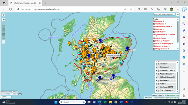
Below you will find information on some specific access issues in places that are popular with Challengers. You can see this information and much more on the Interactive Map.
The nature of the Event and the remote terrain encountered means it cannot be comprehensive and is it is often difficult to access up-to-date information. You therefore need to be prepared to encounter missing bridges etc along the way. If you know of any access issues that you think should be included or have any updates on issues mentioned please contact the Co-ordinators by completing a Vetters’ Information Form or by email at tgochallenge@gmail.com.
Latest news
Spey Bridge at Garmouth – the bridge at NJ341641 has collapsed and is unlikely to be reinstated by this May. Diversion south therefore required to reach the bridge on the main road and then north to rejoin original route. This extra distance and time therefore needs to be factored into route planning.
Culra Bothy – the MBA and Ben Alder Estate have announced that Culra Bothy is to be replaced after it’s closure in 2014. Demolition has been carried out but no work on its reconstruction has been started yet. See www.walkhighlands.co.uk
Luib Chonnal Bothy – will be closed between April 25th and May 19th whilst roof repairs are carried out. Camping near the bothy is being ‘discouraged’.
Kinlochhourn/Loch Cuaich Road – there were significant restrictions on vehicle traffic on weekdays during TGOC25. However the Skye Reinforcement Project tell us pedestrian access will be largely unaffected but on occasions you may be asked to wait for 15-30 minutes during blasting or movement of abnormal loads. We will try and get an update fore May 2026.
Bridge 500m east of Gorton Bothy is no longer there which may cause some route issues when heading for Rannoch Forest if in spate.
Drumtochty forest gates Due to construction work there will be no access to Drumtochty forest at NO 677 800 during TGOC25 – the gates are locked. We will see if this work is continuing for 2026.
Capercaillie Restrictions
These rare and protected wild birds are the largest in the grouse family weighing up to 5kg. The males can be extremely aggressive and may attack if you enter their territory. Cairngorms National Park have just issued the following areas which should be avoided if possible. Ryvoan Bothy to Forest Lodge path, the vehicle access track to Forest Lodge, Dell Road to Forest Lodge track and Forest Lodge to Rynettin path. It is certainly wise to camp well outside their territory as you will not be welcome. There should be warning signs at the start of these tracks. If you wish to change your route to avoid this area please contact the Coordinators.
Forest Lodge/ Nethy Forest

Glen Tanar

The Capercaillie here results in the rangers closing tracks most years. Currently the closed tracks are as shown on the map.
However, if using the Firmounth Road, do keep your eye out for him as in previous years Challengers have encountered the bird outside of the restricted area and we advise not camping anywhere near the restricted area.
Storm damage and landslips
Below is damage we know of affecting regularly used routes. Every year we have a storm somewhere that takes out bridges, blows down trees or causes landslips. Often, in the more remote places, it is Challengers who discover new issues in May.
Shiel Bridge to Glenelg Coastal Path – this path is currently closed between Totaig and Glenelg due to a landslide. https://forestryandland.gov.scot/news-releases/glenelg-coastal-path-closed-after-landslide
Glenbranter Forest – Cowal Way
The local ranger service has reported that the 10km diversion that was in place has now been removed and the Cowal Way once again follows it’s promoted route joining the popular ‘Waterfall Trail’.
Glen Feshie
The path was washed out at the Allt Garbhlach (NN 849 954) in Storm Desmond several years ago and a path upstream to an alternative crossing (NN 851 954) has formed. In normal conditions this is an easy paddle but in spate it requires care to cross and possibly a diversion further upstream. Various attempts to create a bridge here have been washed away in the intervening years.
A further landslip occurred at NN 850 913 in October 2023 on the site of an old landslip. Initially it was difficult to pass but stabilised withing a few weeks and a report from Chris Townsend in March 2024 shows no further damage had happened over the winter and no problems were reported getting past it during TGOC24.
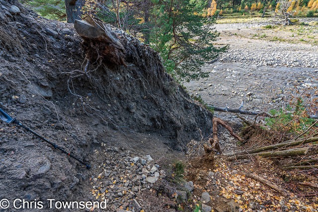
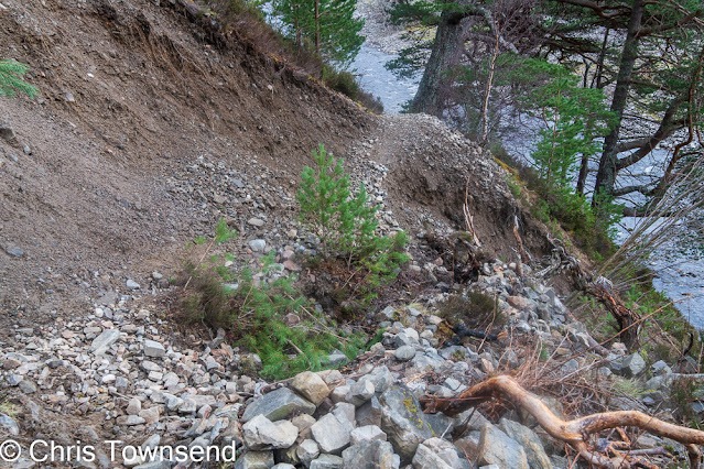
Allt Gharbh Ghaig

A longstanding landslip at NN 787 820 on the path above the Allt Gharbh Ghaig remains difficult to pass. Attempts to repair it have generally headed down to the river and we advise you do not try to cross it.
The best option is to head up the steep grass gully (on the left in the photo) and once on level ground traverse above it to rejoin path.
Glen Doll
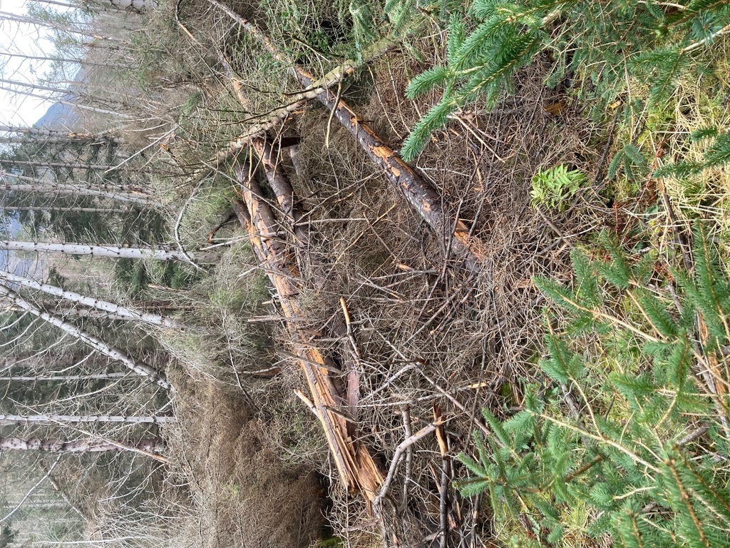
The lower section of Jock’s Road remains impassable due to wind-blown trees caused by Storm Arwen in 2021, and will remain so for. TGOC25 though there are now longer term plans to clear it.
The track on the south side of the White Water, known as the Donault Road, is the only viable alternative. The bridge across the White Water NO 247 767 was in good condition in Spring 2024.
The lower section of the Capel Mounth Road is also blocked requiring a diversion along the forest edge to pick up the track from Moulzie.
Both problems are long term with no plans to clear the badly affected areas.
Bridges
One of the challenges of the Challenge is dealing with unexpected issues such as a missing bridge. We cannot give a comprehensive list but here is what we know currently in areas popular with Challengers, focusing on bridges over potentially unfordable rivers. If you you have any recent experience of any of these crossings that varies from the information given please let us know.
Knoydart

Several bridges over side streams on the Mam Barrisdale path were reported to be in a poor state of repair in 2024 though they should be fordable in all but the most extreme conditions.
The old bridge at Carnoch NM 865 964 has been replaced with a new sturdy one that we hope will resist winter storms for many years.
The bridge over the Allt a’Ghille Chruim at NM 879 945 was reported to be in a poor state of repair in 2022
Callop
The bridge over the River Callop near the Glenfinnan Monument at NM 909 804 reopened after repairs in March 2025.
Glen Kinglass/ Abhainn Shira
The bridge still shown on many maps at NN 185 402 has been replaced by a new bridge around 800m downstream.
The bridge across the Abhainn Shira at NN 233 417 is present but the bridge across the Allt Ghabhar is no longer there. In spate this will require a diversion north to a footbridge at NN 237 425 near Clashgour.
Glen Strathfarrar
The bridge at Inchvuilt NH 230 387 became dangerous and was removed by the estate in 2013 with no plans to replace it. The ford upstream is dangerous in all but the most benign conditions necessitating a road walk via the two Monar dams.
The bridge at NH 262 383 was renovated in 2022 and is now in good condition.
Invervigar Burn
The bridge shown at NH 336 056 is still shown on Ordnance Survey maps despite being absent for several decades! There is, however, an unmarked bridge upstream at Achadh-nan-darach NH313056.
Glen Banchor
The bridge at NN 648 984 was washed away several years ago but remains on some reputedly up-to-date maps. Other bridges are shown across the Calder on older maps but there are none, other than the A86 road bridge. The crossing of the Calder can be impossible in spate. The best FWA from Laggan to Newtonmore is via the minor road in Glen Truim.
River Dulnain
The bridge at Dalnahaitnach (NH 855 201) has long gone but is on older maps. There is now a new track along the north side which leads to the bridge at NH 865 212.
The bridge at NH 789 135 has been swept away. If you can ford the River Dulnain the bridge at NH 790 134 across the Feithlinn appears to be intact. The bridge at NH 765 121 is, we believe no longer there – any recent information appreciated – please email the Coordinators.
Glen Tanar – bridge on Mounth Road
The bridge at NO 406 899 on the Mounth Road has been closed on safety grounds as the banks supporting it have been seriously undermined. This is a popular Challenge route and in spate conditions it will not be possible to ford it safely.
The bridge at NO 413 908 is still intact as is probably the best alternative as we are uncertain of the status of the footbridge at NO 401 893.
Glen Tromie

The Tromie is a difficult river to cross even in moderate water conditions. The bridges at NN 753 923, NN 753 913 (unmapped), NN 755 911 and NN 764 890 have all gone.
The walkway at the dam at NN 763 881 is still available and the only feasible crossing downstream from Tromie Lodge if in spate. If approaching directly from Newtonmore or Loch Cuaich the dam crossing will need to be used as your main route or added as an FWA
Glen Feshie
The only bridge across the River Feshie upstream of the road bridge at Feshiebridge is near Stronetoper at NN 851 965.
All other bridges, shown on older Ornance Survey or Open Source maps do not exist. Please note that the ‘Snap to Path’ functions on some digital mapping will suggest crossing the River Feshie at Carnachuin. This bridge was washed away many years ago and it is not an ideal place to ford unless the water is exceptionally low.
The best place to ford the River Feshie is around NN 846 918 where it is wide and braided. In normal conditions this is a relatively simple paddle but in spate it is impossible to cross safely so you will need a FWA via the bridge at Stronetoper.
Deeside
Many bridges were damaged or washed away by Storm Frank in December 2015 and repairs have taken many years. The following have been replaced or repaired or escaped significant damage:

- Luibeg Burn at NO013942
- Derry Burn bridge near Derry Lodge at NO 040934
- Victoria Bridge near Mar Lodge NO 102 895.
- River Quoich road bridge at NO 117 910
- Punch Bowl bridge at NO 114 913
- Pollhollick bridge NO343965
- Cambus O’May bridge at NO420976
The only bridge we know of in the area that remains closed is over the Derry Burn at NO 039 958
Glen Muick

Allt Darrarie Bridge at NO 318 838 has been repaired / replaced several times in recent years. It was in good order in May 2024.
The bridge at Mill of Sterin NO 350 929 was demolished in 2024 and will not be replaced.
Glen Doll
The bridges at Moulzie NO 281 773 was washed away and had not been replaced in 2022. The bridge at Bachnagairn NO 254 796 which was previously washed away was replaced in 2020 and reported as in good condition in 2023. Any recent information gratefully received. Please contact the Coordinators if you have been this way in the last few years.
River North Esk – inc. Tarfside and Edzell
The following bridges are absent or unuseable:
- Woodhaugh, NO491790, is deemed unsafe and has been blocked by the estate
- Turnabrain, NO501789, is no longer there.
- Dalhastnie suspension bridge, NO 578 771, is usually locked.
- Shakin’ Brig, Edzell. Though still standing itwas badly damaged in 2023 and deemed unsafe. In August 2024 it was barriered and there were no signs of plans to repair it in the near future. Please do not attempt to use it.
The only serviceable bridges across the River North Esk are at:
- Gleneffock, NO 457 789
- Dalbrack, NO 469 782
- Fernybank, NO 534 782
- Rocks of Solitude, NO 580 740. Relatively new (not on all maps) allows access to Blue Door Walk
- Gannochy, road bridge NO 601 709
- North Water Bridge, NO 653 661
Glen Dye/Fetteresso
The bridge marked at NO 655 867 at Heatheryhaugh is in fact a wire cable and basket which is normally locked and therefore unusable. The River Dye is rarely easy to ford so the only option is the road bridge at NO 651 860.
Bothies
For MBA bothies please check for any current issues via the bothy location map on the MBA website. Peanmeanach is closed long-term. Culra Bothy news mentioned above.
MBA bothies can be busy at times so although you should always be made welcome by other occupants be prepared to camp outside if your chosen bothy is overcrowded.
Non-MBA bothies should be seen as a bonus if they are left open for walkers, but we advise not to rely on their availablilty.
Estate Requests and Camping Restrictions
It should be noted that the Scottish Access Code does not give you unlimited access to walk or camp. In particular you are reminded that you cannot walk through the policies (essentially the grounds) of inhabited houses or businesses. This includes tracks through farmyards – please do not be offended if you are asked to find another route. If you want to camp near an inhabited building you should seek permission whenever possible.
Some estates, even though the Access Code would allow walking through or camping, have made reasonable requests with which we ask you to consider. In addition there are wild camping bylaws in place in the Loch Lomond National Park.
Loch Lomond National Park
There are bye laws restricting wild camping by many of the lochs in the Loch Lomond and Trossachs National Park. Places have to be pre-booked (for details click here) and fines may be imposed if you do not have a permit. However it is relatively easy to avoid them and camp elsewhere.
Glen Feshie
The estate requests camping be confined to the area around Ruigh–aiteachain Bothy (NN 847928), or further upstream.
Glen Muick
Balmoral Estate request no camping because of the specific characteristics and sensitivities of the area around Spittal of Glenmuick and Loch Muick.
The nearest bothies are at Gelder Shiel, Glas-Allt Shiel (north side of Loch Muick) and Shielin of Mark and it is acceptable to camp outside the bothies.
Glen Lee
Dalhousie Estates advise the the shores of Loch Lee are often used for night fishing and request wild campers avoid the area. If you want a restful night we advise camping before Loch Lee or pushing on to Tarfside
Glen Mazaran
The estate requests Challengers do not walk past Glenmazeran Lodge and are well within their rights to do so with regard to the Access Code. Please take the right fork at NH 744 227, cross the river and drop to the minor road at NH 748 224.
Other access issues
Railways – including Dalwhinnie level crossing
Network Rail lines. It is against the law to trespass on any current railway line even in remote places. The places where we frequently have to decline sections of route because of potential trespass are:

- Accessing Essan bothy south of Loch Eilt including the rail bridge at NM 788 827
- Rail bridge over the River Spean near Tulloch Station at NN 359 801
- Accessing Corrour Station from Loch Trieg, in an attempt to avoid the boggy path
- Dalwhinnie level crossing, NN 633 846 has been closed by network Rail indefinitely due to safety concerns. There is no access via the station bridge. To get to the village use the underpass at NN 635 841
If any of the above or any other section of live railway line appear on a route it will be rejected.
Disused railway lines. These fall within the access code and you can try and follow them. However unless they have been converted into footpaths or cycle tracks you may find it not worth the effort with dense undergrown, fences and barbed wire to contend with.
In particular attempts to follow the old line in Angus to the east or west of Forfar have usually ended with Challengers resorting to minor roads instead.
Parts of the old “Puggy Line” tramway through the Leanachan Forest to Fersit are useable but most of the bridges are missing necessitating some scrambling and issues if the burns are in spate.
Construction Projects
Access during the building of wind farms and hydroelectric schemes is not often restricted but heavy plant vehicles are likely to be operating in the area. For your own safety ensure you are visible and comply with any reasonable diversions or requests from construction workers you may encounter.
In recent years several small scale hydro-electric projects were reported (including Glen Etive, near Bendronaig Lodge and Allt Garbh nr Loch Affric, Glen Buck and Glen Prosen). It is likely that more will appear which we often do not know about until a Challenger comes across them in May. There are no access restrictions that we know of though new tracks and the obliteration of some old tracks may affect navigation.
Forestry – felling and windblown trees
If your route goes through commercial forestry there is always the chance forestry operations may force you to adjust your route. Please obey any signed diversions and follow any instructions given by forestry workers.
Winter storms many cause tracks to be blocked by windblown trees. Forestry and Land Scotland have asked us to pass on the message that these should be treated with extreme caution due to the risk of “spring back” if you try to climb over or under them. If at all possible seek another route.