


This is the report on the analysis of the TGOC East 2026 Survey, which asked those who participated in the event for feedback on various aspects from event application to completion.
To put the numbers of participants in context, TGO Challenge East 2026 was its inaugural event, and we had a total of 38 applications from the UK, Israel, USA, Denmark and France, with 27 participants starting the event, 25 of whom made it to their respective finish point. We had an excellent response to the survey of 20, which amounts to a response rate of nearly 75%.
A big thank you to all those who took the time to complete the survey: it forms one of the ways we can judge what went right and what went wrong on the event, and allow us to modify processes, procedures and routes, as well as trying to improve the service that we give.
Survey Analysis
The following paragraphs provide feedback on the survey questions and also some of the actions that we, the Coordinators, will take to address the issues raised. The percentages quoted are of those who submitted a response to the survey (20), not of the whole number of Easters who were requested to take part in the survey (27).
Online Forms
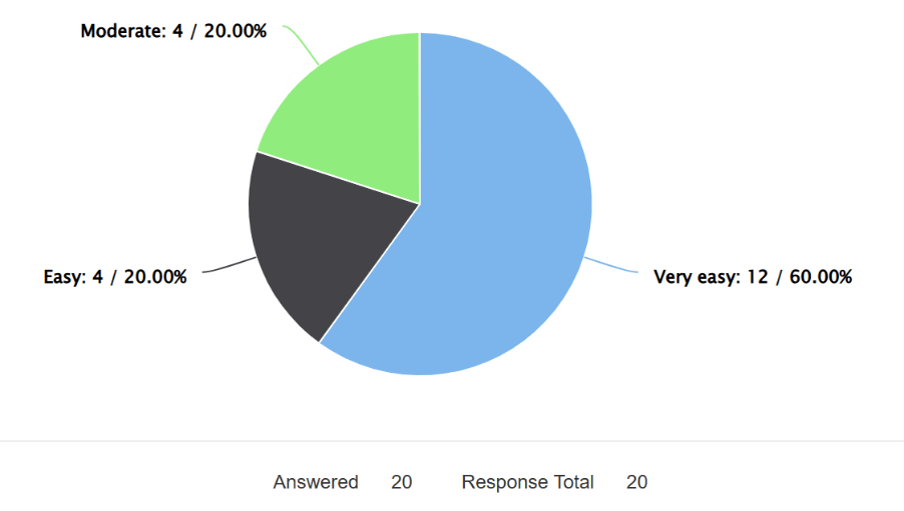
The first few questions were about the ease of completion of the Application, Route Preference and In Case of Emergency forms. The responses were almost identical for each of these forms, with no reports of any difficulties. The output for the Route Preference Form is shown in the pie chart.
One of the comments received on this section stated: ‘I would like the route preferences as a spreadsheet so I could order them by grade, distance etc’. For future TGOC East events, while we don’t intend to make the Route Preferences spreadsheet available directly from the website, we will include on the website a pdf of the Route Preference Form that has the routes sorted by route grade.
TGOC East Website Information
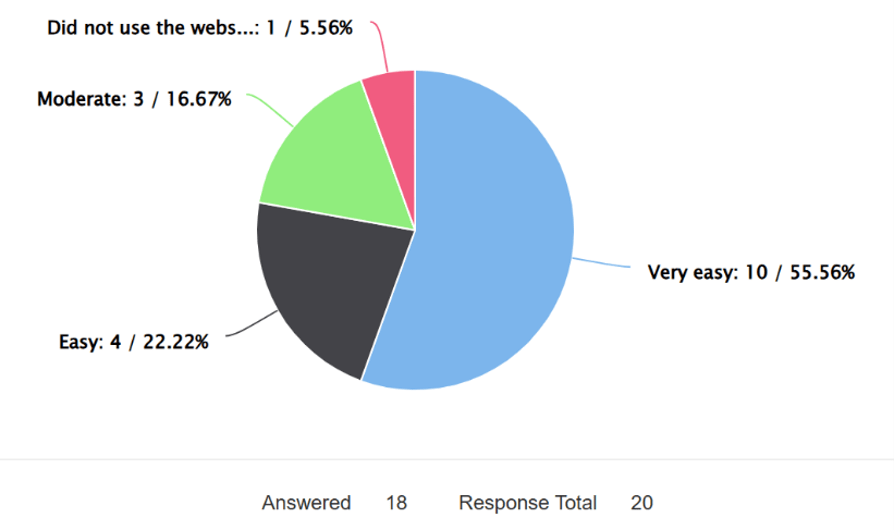
The next set of questions was about the information provided on TGOC East on the TGO Challenge website (www.tgochallenge.com) and how easy it was to find, use and understand the information provided.
The three questions asked were about general event information, the TGOC East Route Options, and the Forms and Resources webpage. Once again, the responses for each of these questions were very similar with no reports of any difficulty.
The output, shown here for the route options webpage, was typical for the TGOC East website data as a whole.
Information Supplied on Allocated Route
We supplied all participants with the following information on their allocated route:
• A written description in the standard Route Sheet format that is used for the main TGOC event.
• A Route Information Guide.
• A complete set of GPX files.
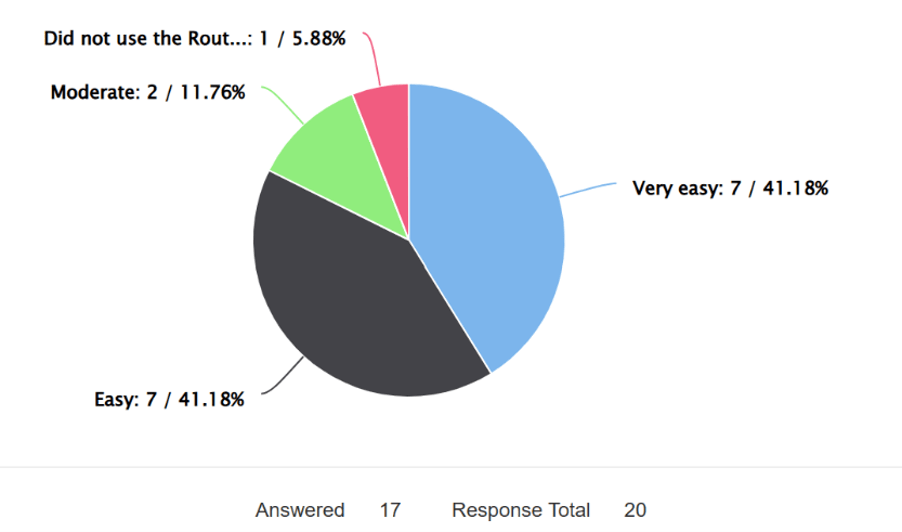
Route sheet: There were no reports of participants finding this difficult to use and understand. The main comments on this question were all positive and mostly to the effect that the written Route Sheet was only used for overview purposes, with the GPX files being used to provide the detailed map information.
One overseas Easter reported: ‘knowing/understanding Scottish descriptive words/place names took a bit of learning’.
We would like to assure them that Scottish descriptive words and place names are a mystery to many, many Challengers – even those that hail from Scotland! Nevertheless, for TGOC East 27 we’ll provide a glossary of the Scottish words often used on OS Maps, to assist in some understanding of Gaelic and Scots placenames.
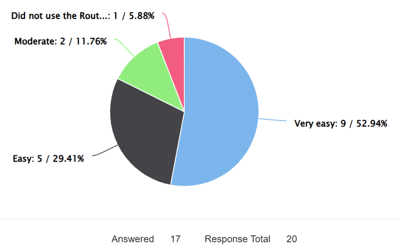
Route Information Guide: This was intended to provide additional information that doesn’t appear in the Route Sheet and give more descriptive information about the allocated route on such items as warnings, advice, camping, accommodation, resupply, as well as some information on points of interest.
We have had some reports of issues on items such as access, bridges and difficult terrain that caused Easters some concern during this year’s walk and we will check out these issues and update the documentation accordingly for next year.
GPX files: The GPX files supplied were one that covered the complete route, and a Zip file containing individual GPX files for each day of the walk (including the Foul Weather Alternative routes).
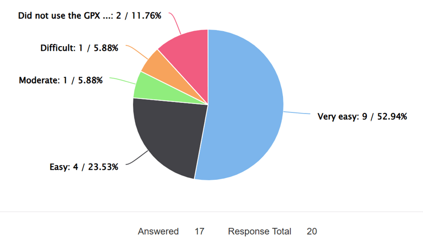
The majority of those who responded found them easy to use; however, one Easter found the OMN digital mapping platform difficult to understand and use stating ‘For me, the difficulty was in using the suggested OMN application. I found it difficult to figure out how to use it on both the computer and the phone. The OMN app lacks some features, such as the ability to determine the distance between two points (i.e. how far it is from where I am to a certain destination)’. Another section of their comment states ‘It would be helpful to provide challengers with a variety of mapping applications to choose from, or options to consider and do our own research. I hadn’t used mapping apps in the UK before, and since the TGOC recommended the OMN software, I went with it.’
We take on board the above comments and will modify the advice given so as to provide names of other mapping applications used by Challengers; however, it should be recognised that each mapping application does have its pros and cons, with all options having good and bad features. Many Challengers use a combination of mapping applications to perform separate functions such as plotting, data analysis, file management and use in the field.
Mick tends to use the OS Maps application for route planning (it has a good snap-to-route function, but you have to be careful to check it all) and for elevation assessment; but then uses OMN as this app is very good at GPX file management (whereas OS Maps doesn’t allow sub files) and the printing of maps; and finally, for navigation Mick uses the Memory Map application for digital navigation backed with the paper maps printed from OMN. Ali tends to use Outdoor Active for planning as it also has a good snap-to-route feature, but as it can’t deal with sub-files she also uses OMN for file manipulation.
As it stands, the only mapping application that is provided for free to Challengers and Easters is the OMN software, so going to other mapping platforms will incur additional cost.
Route Grading of Allocated Route
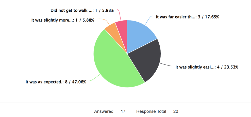
Each participant was given a choice of routes based upon the Coordinators’ assessment of the participant’s Experience Form. A survey question asked if the grading of the allocated route aligned the participant’s actual experience of the route. The responses showed that only one Easter thought that the allocated route was more difficult than expected, with all others who walked their route responding that it was as expected or easier. See below:
Given the responses, it would appear that we got the gradings about right – we wouldn’t want Easters to feel that there routes were far too difficult for them. During the entry phase, we give the opportunity for applicants to query our grading assessment if they believe that their prior experience should allow them to take on a more demanding route.
Enjoyment of TGOC East
We asked if participants felt suitably prepared for the event in terms of information, equipment and fitness, and what, if anything, would you do differently next time?
The overall response to this question was very positive with Easters indicating that the information supplied was generally excellent, most of the kit was appropriate and the levels of fitness were enough for the event. The main positive theme of the comments was that of the camaraderie experienced with other Easters and Challengers. There were a few points in the comments (with our one line response in italics) that provided some further insight, which are bullet pointed below:
- Boots v trail shoes: an old chestnut for Challengers and a question of preference, but you need to take into account both the weather and the route.
- Taking too much (kit/food): it’s a difficult balance to get right and given the unpredictable weather conditions, it always better to err on the side of safety.
- The route out of Braemar was incorrect and needs to be updated: this will be checked and modified as required. Could the Easter who submitted this comment please email us with more detail of the route problem so that we can review and update it for next year?
- Add in the odd B&B/hotel stop: TGOC East has options within the Route Information Guides on accommodation. It’s good to have the odd night of comfort – you are on holiday.
- Try digital maps: like them or not, it’s the way of the world and the majority of Challengers now use digital mapping; however, it’s imperative that you have a back-up option for whatever primary navigation method that you use.
We will review all the comments and try to address all issues raised and update the TGOC East documentation accordingly. Additional advice, if required, will also be included in the various documents.
Will Easters come back for more?
One of the aims of TGOC East is to act as a feed-in event to the main Challenge.
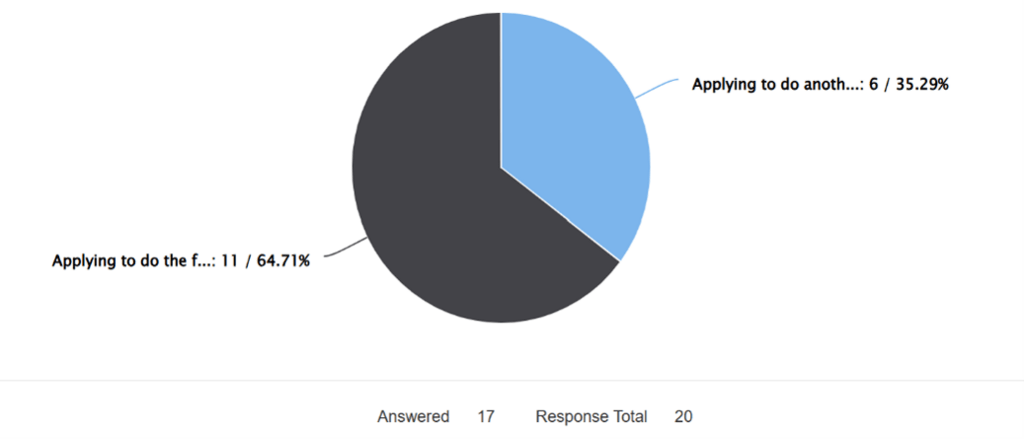
We asked if Easters intend to return to the TGOC East or TGO Challenge in the coming years.
Despite the dreadful weather at the start of TGOC East, with cold, rain, snow, hail and high winds 17 out of the 20 Easters who responded intend to come back for more! We did warn Easters that this event is very addictive and we are delighted with this response… all we need now is to see your names appear on the application forms for the events in the Autumn.
Challenge Control
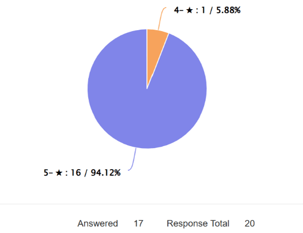
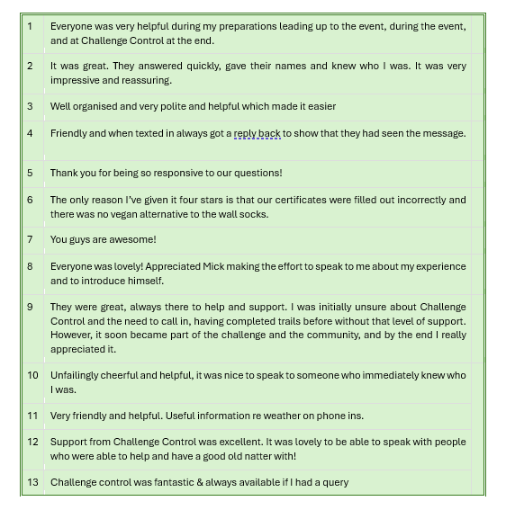
We asked what star rating (1 to 5) would Easters give for their experience with Challenge Control. Generally, first-timers to the Challenge have some trepidation of having to phone Challenge Control, even though we try to allay their fears.
This is an excellent response, and we are aware of the issue that caused the 4-star rating and have addressed this post event (our apologies). We think that it is worthwhile adding all the comments provided, so that future Easters can see what to expect and realise that it’s not scary at all!
TGOC East Overall Experience Rating
We asked what star rating (1 to 5) would Easters give for their experience of the TGOC East event.
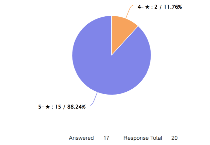
Getting a nearly 90% five-star rating on this, our inaugural event, is amazing, and the rest of four-star means we must have done it about right. Thank you all for this excellent response!
Specific issues during TGOC East: We had some feedback on a couple of navigation/access issues that we will address before TGOC East 27, but other than those, that was it.
Further comments and suggested improvements on TGOC East:
- Three Easters suggested a TGOC West.
- One said that sometimes the days were too short.
- One suggested that experienced Easters should be allowed to plan their own route.
Our responses to these suggestions are:
- We need to prove that TGOC East is a viable event before introducing further events… but the idea has crossed our minds too.
- The length of days (in terms of distance walked) is aimed at inexperience backpackers . However, we do say in the Route Information Guide that the option to walk on is always there if the Easter want to do this, but we don’t want to scare people off the event by making it too difficult. We also rejigged several routes to fit in with the particular Easter’s shorter available timescales, which meant longer days, so we are flexible.
- At present, we would like to maintain TGOC East as described, where routes are pre-set. Once the event has ‘bedded in’ we may revisit the structure to see if other options can be introduced.
Conclusion
We’re really pleased with how TGOC East went and we’re extremely please that from the survey it seems most Easters not only enjoyed the challenge of the event but experienced a great welcome from the Challengers on the main event. There are a few items to address, but it seems that we got it about right. Hopefully, next year’s weather will be a bit more forgiving, but a bit of rain/snow is always welcome.
In order for TGOC East to succeed as an event over the coming years, it’d be great to see Easters come back for more, and for more applications from those new to the event to be received. Both TGO Challenge events tend to become known by word of mouth or via social media, so please spread the word! If you are a member of other walking/backpacking groups that you consider would be a good fit for us, please let them (and us) know so we can both benefit from each others communities.
If you have any questions/comments on this survey report, please feel free to contact us at tgoceast@gmail.com – we’d be pleased to hear from you.
And finally, a really, really big thank you to all Easters.