

Most Challengers create their routes using digital mapping and in recent years 80% of submissions have been accompanied by GPX files, which both Vetters and Coordinators find very helpful. For those Vetters that use them, it speeds up the process of assessing a route quite significantly and can be used to elucidate sections of route description that are a little unclear.
We know some new and regular Challengers, particularly those from overseas, find providing a detailed written route description difficult and time consuming. We hope GPX led routes will make the process easier for those comfortable using GPX files.
Click on the blue boxes below for more information and/or check out these YouTube videos:
What is a GPX led route?
Accurately plotted GPX files will be used by your vetter and the Coordinators, to assess your route rather than a detailed route description. You will need to:
- Produce accurate GPX files for each day and for each FWA of your route.
- Give a minimal route description just 2-5 place names will suffice (see examples).
- Provide distance, ascent and overnight halt point for each day.
What are the advantages (and disadvantages) of GPX routes?
The advantages are:
- Time saving for Challengers. For those who would produce GPX files anyway there is no longer the need to spend time on a detailed route description.
- Time saving for Vetters. A description led route means your vetter generally has to plot it themselves before they can assess the route. It is also much quicker to check ascents and distances.
- Reduces ambiguity. With a written route there is sometimes more than one interpretation of where the written route description goes. With a GPX file there is only one option! This can also save time for the vetters and reduces the need for some revisions.
- Challenge Control. If we are worried about you during the Event it is much quicker and easier to bring up your GPX files and work out where you may be or how we help you. We can also pass on your files to the Emergency services if necessary.
Disadvantages:
- You need to be comfortable with digital mapping and producing, using and downloading GPX files.
- If you don’t produce GPX files when you route plan it may be time consuming. If you haven’t done this before it may take you some time to learn it.
If you are not used to using GPX files – don’t worry! There is no pressure from us to use GPX files. We are still more than happy to accept the more traditional detailed route descriptions that have been used for years. It can be quite fun following a route description and transferring it onto a map!
How does it differ from a traditional TGO Challenge route sheet?
The main difference is that you do not need to provide a detailed written description for your vetter to follow We just need 2-5 place names to give an overview of your day and your GPX files will do the rest. We ask you to include in the brief description:
- Include towns or villages.
- any phone in points that are not OHPs
- Significant summits or ridges. For example you can say “South Glen Shiel Ridge” without naming individual summits.
- Significant unbridged river crossings.
See the examples below for more details.
Examples
Example 1 . John Smith is taking a lower level route. Below is an example of a day on his route from Garva Bridge to Newtonmore. For his vetter to follow this without a GPX file it would need to say:
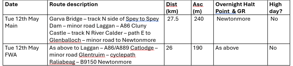
A GPX led route could simply say:
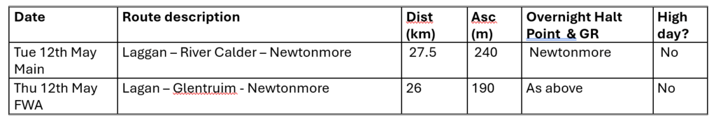
Including the River Calder in the route description alerts the vetter to the need for a FWA (which has been given).
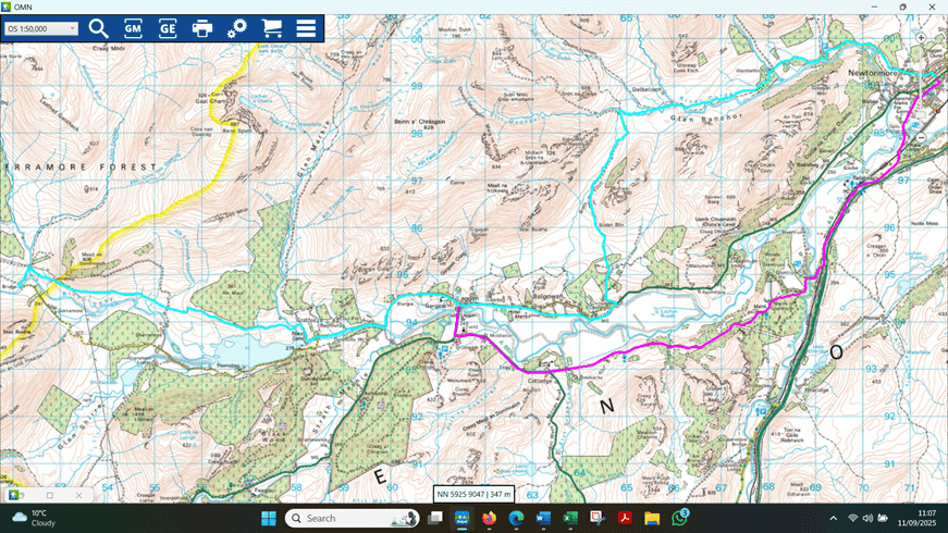
It would be accompanied by GPX files – SmithJ 12May main and SmithJ 12 May FWA. So John’s vetter will see this day’s route as:
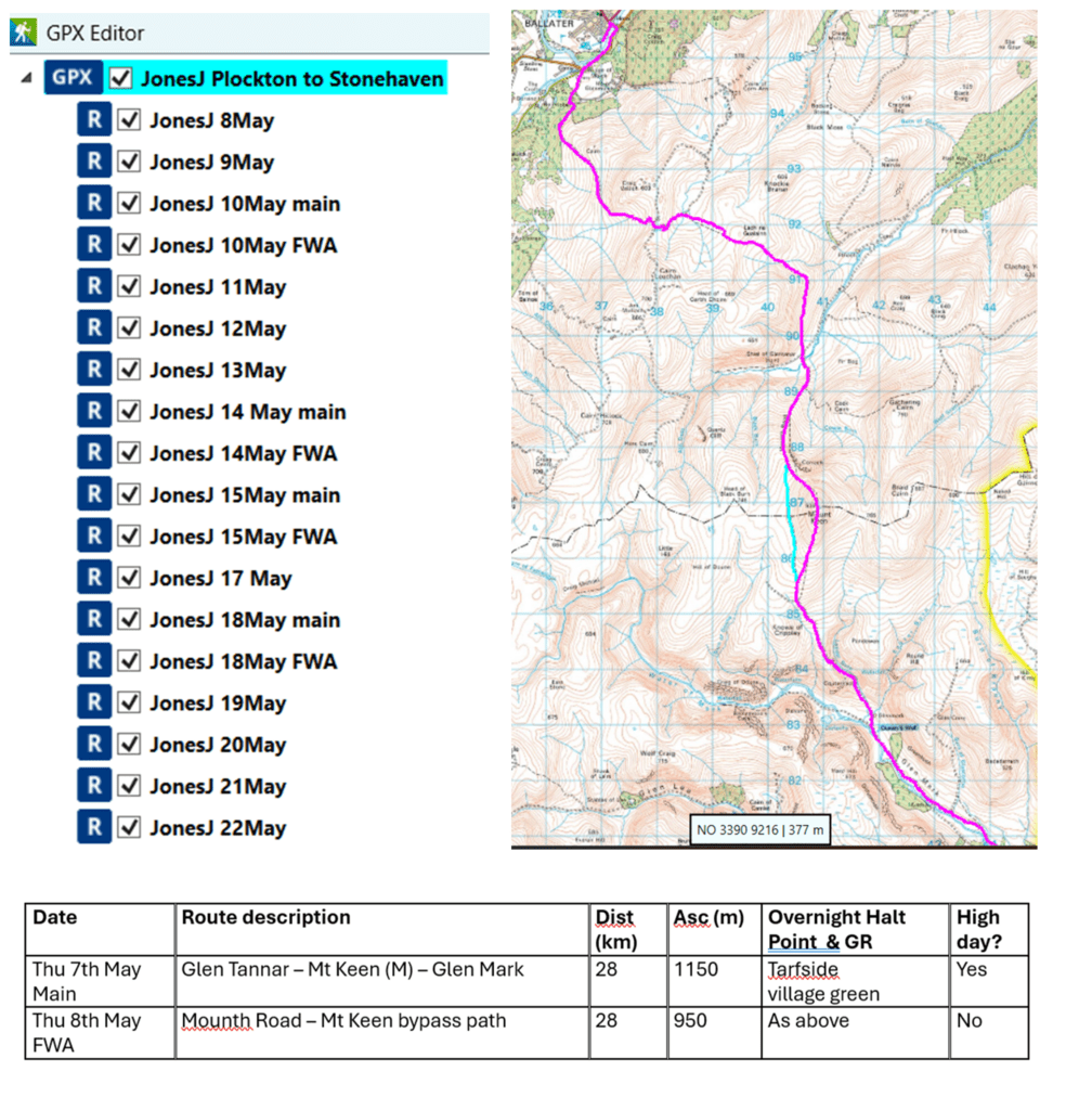
Example 2 Janet Jones has some high days on her route with one going from Coylumbridge to Derry Lodge. A description led route description could read:
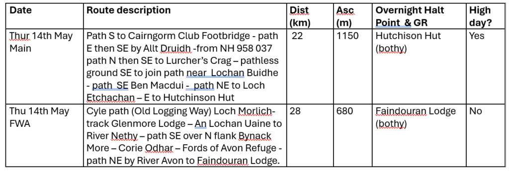
A GPX led route description would simply say:
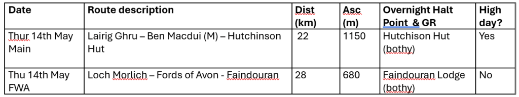
The (M) next to Ben Macdui signifies it is a Munro but for those who don’t tick Scottish hill lists (S) for summit would be fine. Janet is taking a multiday FWA which will need to be continued on her next day’s route.
It would be accompanied by GPX files – JonesJ 14 May main and JonesJ 14 May FWA. Her vetter will see this day’s route as:
How do I produce and present my GPX files?

How you produce your GPX files will depend on the digital mapping application you use. There is a video on the TGO Challenge YouTube channel showing how to download your files on the most popular mapping apps, in a form that the Vetters and Coordinators can use. Click the image to watch it.
There are two ways to present your GPX files to us.

- One or two files with individual days and FWAs as subfiles. This is our preferred option, but not all platforms (eg OS maps) let you do this. GPX studio is a good tool for linking individual days (click on the image to the right for a video showing how to do this).
- Separate files for each day’s main and FWA routes. If you are unable to create subfiles send individual files via a shared folder or zipped file and the Coordinators will link them together.
When labelling your files it is helpful if you can include your name (or your Group Leaders name) the day it refers to in your daily files. eg: JonesJ 14May main/ JonesJ 14May FWA
Please note we cannot accept your whole route as one long GPX route – it must be divided into days.
Once you are happy with your GPX files go to the online route sheet.
Why do I still need to fill out an online route sheet form?
There is a lot information on the route sheet, other than the route description, that is essential to the Coordinators and your Vetter.
- Data (start/finish points, PIPs, pinch points, Loch Ness ferry, Park Hotel dinner requests) is automatically pulled from the route sheet that is vital for organising the Event and it’s safety procedures.
- Ascents and distances are important for your Vetter. As well as looking at each individual days they also look at the balance of your daily ascents/distances across the route and review that in light of your experience. That’s most easily done with all the figures in one place.
- Overnight halt points are useful for Challenge Control who, in an emergency situation may need to look quickly at multiple route sheets to see who may be in the area of concern.
How do I submit my GPX led route?
You will use the same online route sheet as is used for traditional description based option. Just click the GPX led route option when prompted so the Coordinators know you want your GPX files to be used by your vetter.
After the route description section you will be given the chance to attach your files. if you are submitting separate daily files you may find it easier to send them by email in a zipped file or give access to a shared folder.
How do I revise a GPX led route?
You will need to:
- Revise your daily GPX files and download them from your mapping app.
- Use the link sent to you once your route was submitted to access your online route sheet.
- Check the route description – for minor changes you may not need to change anything but please adjust distances/ascents/OHPs if there is a significant change.
- Attach you revised GPX files.
- Update the version number i.e. your first route submission is Version 1 so, if this is your first revision, update it to Version 2.
- Use the “changes” box to list the days where you have revised so your vetter knows where to look.