
Choosing your route
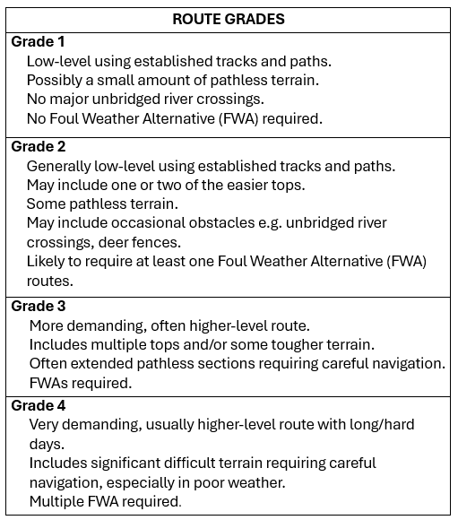
To help you choose your top 3 route preferences you will find below, listed by start point, an outline of each route including average daily distance and ascent figures, highlights, accommodation and resupply options. They are also summarised in the Route Options Table.
Each route is graded in terms of difficulty. The Coordinators will let you know which grade(s) of route you can choose from once your Experience Form has been assessed.
TGOC East routes do not generally follow lines you will find in guidebooks or on websites. Most are created from routes walked by the Coordinators or the TGO Challenge vetting team in recent years. Where possible we have recced some sections where our knowledge is more distant. However, things can change since we last had Challenger feet on them – gates we found open may be locked, bridges washed away by winter storms, landslips may obscure paths, and new tracks and fences constructed. In addition, conditions on the day may make sections we have found easy going become difficult. We warn of significant river crossing, but in severe weather even minor burns may become hazardous.
Click on any of the green boxes to see more or less information.
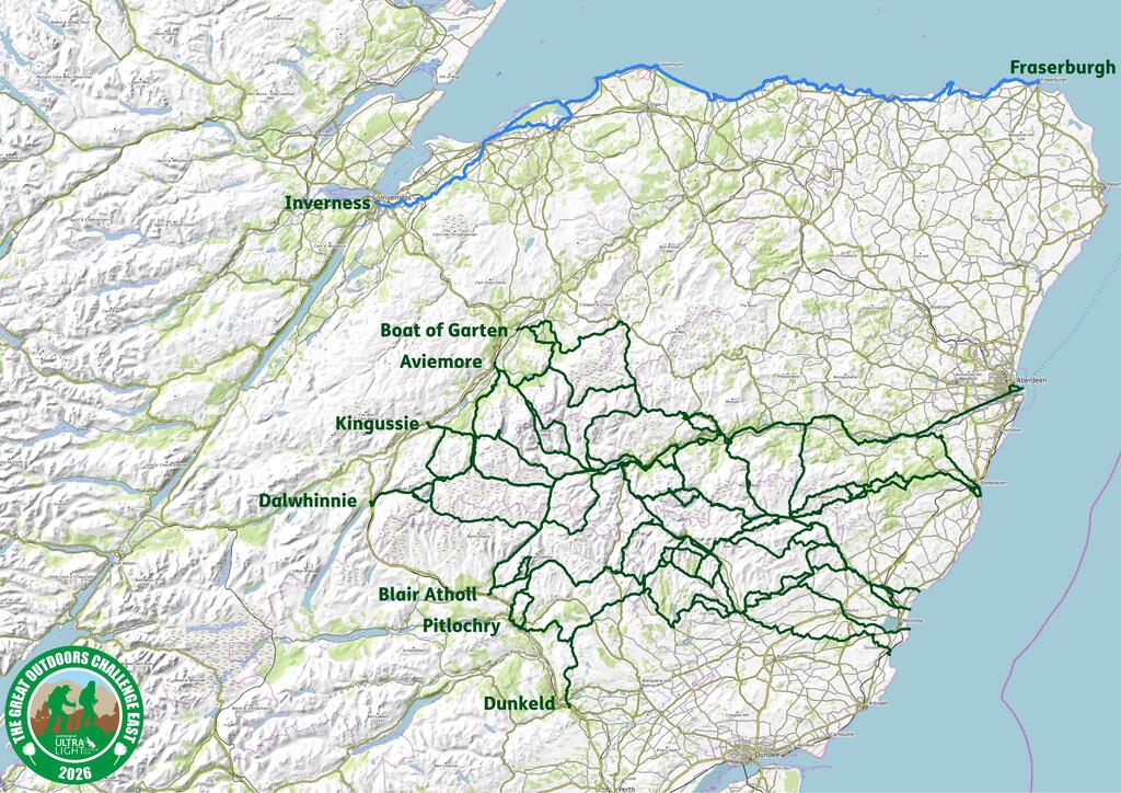
Inverness
The capital of the Highlands is easily accessible by train, bus and plane with plenty of accommodation options it gives access to the beautiful Moray Coast.
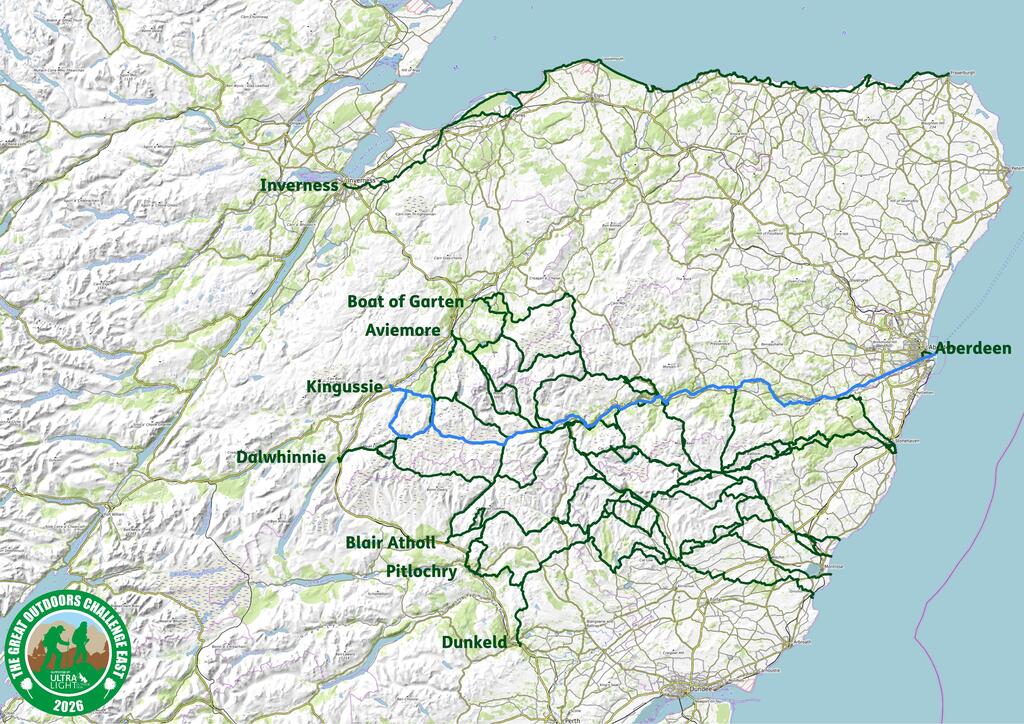
Route 1 – Inverness to Fraserburgh – Grade 1
Duration: 8 days Total Distance: 194km Total ascent: 2050m
Average day: 26km & 210m ascent
Start Days: Thursday 14th May only
The walk is soon out of the urban areas of Inverness onto coastal paths through sand dunes, past links golf courses, long beaches and coastal cliffs taking you through a multitude of fishing villages. There is a good chance you will be basking in sunshine whilst other Challengers are reaching for their waterproofs!
This a less frequented route so it doesn’t necessarily provide the social aspects of other Challenge routes but it takes you through many historic coastal towns and villages, providing lots of opportunities for hotel and B&B accommodation and regular access to shops for resupplies.
With an average of 25km+ per day, it still requires a good level of fitness and determination.
Terrain: Mostly on good path and tracks with some walking on minor roads.
Toughest days: Longest day is 30km but on relatively flat and on easy ground. The most ascent in one day is 630m but the scenery makes it worth the effort.
Highlights:
- Portsoy, Gardenstown and Crovie and for all Local Hero fans Pennan and it’s phone box!
- Beautiful coastal scenery including Fiddler’s Rock
- Historical sites – Culloden Battlefield, Cawdor Castle and the Museum of Scottish Lighthouses in Fraserburgh
- Potentially an ice cream every day!
Resupply options: too many to list, almost every village has a shop and/or café.
Accommodation: Most nights you will have access to a campsite and/or B&Bs and hotels. 3 wild camps are included but there are options to stop short or push on for formal accommodation.
Sociability: Unlike other TGOC East routes this does not intersect with other routes but you may meet some Challengers along the way.
Boat of Garten
Arrive in style on a steam train – Woo Woo! Boat of Garten is a small village on the Speyside Way north of Aviemore. You’ll need to pick up supplies in Aviemore before travelling up to the start point.
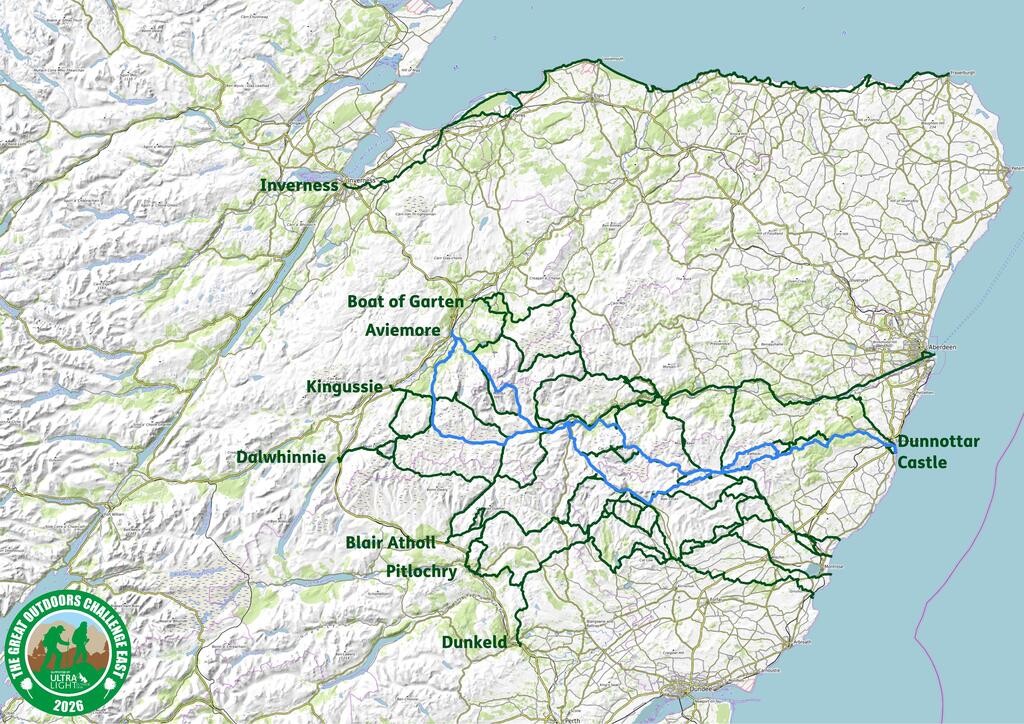
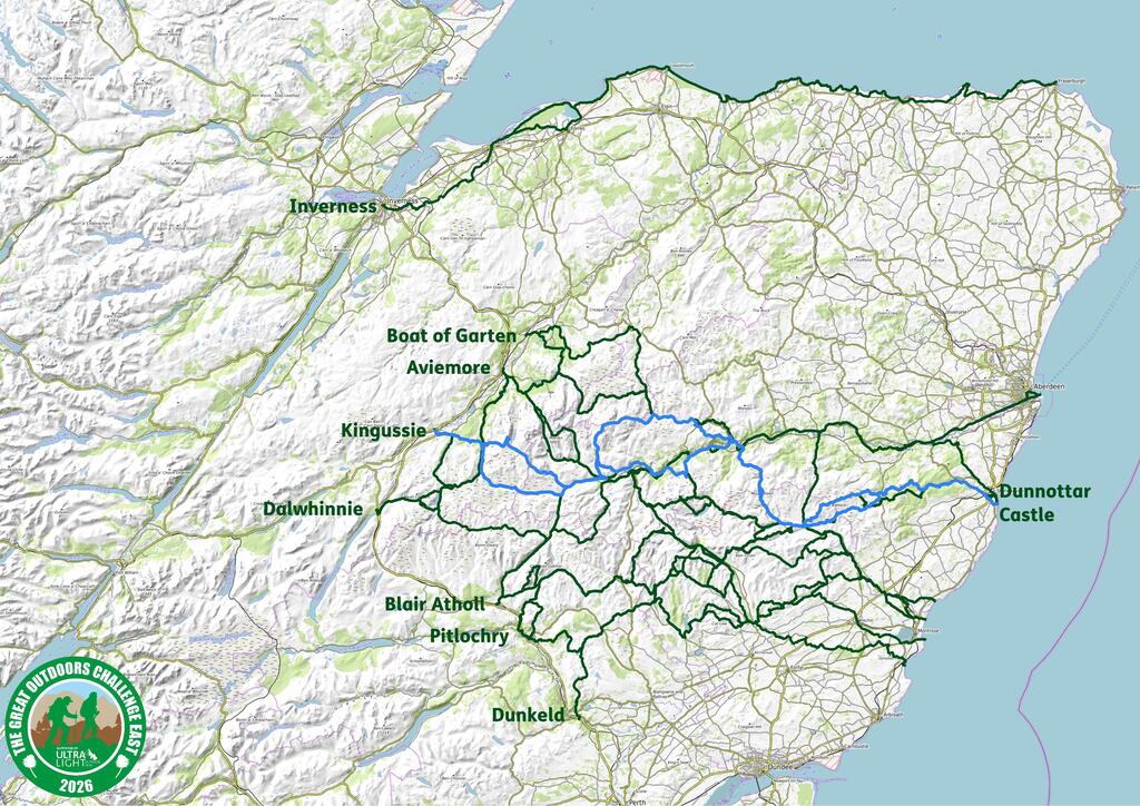
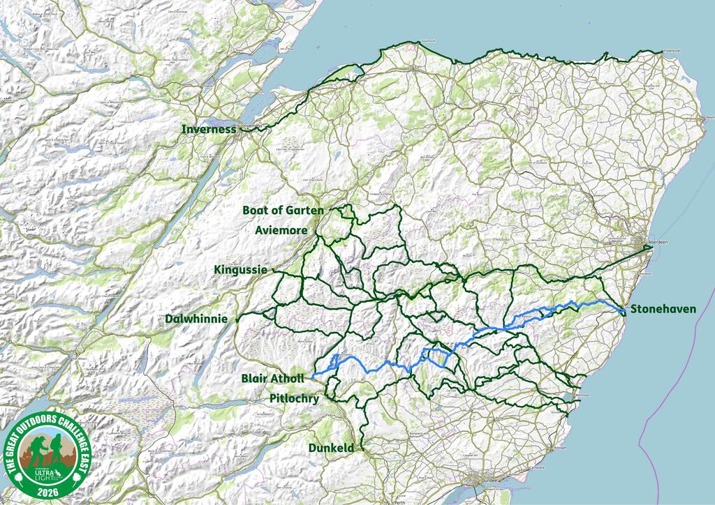
Route 2 – Boat of Garten to Stonehaven – Grade 1
Duration: 7 days Total Distance: 155km Total ascent: 2120m
Average day: 22km & 275m ascent
Start Days: Thursday 14th May to Saturday 16th May

This low-level route initially takes in a some areas less well-travelled by Challengers, but is quite stunning. Setting out on forestry tracks, then on open ground to Tomintoul, the route leads you into secluded glens and on to Ballater. From here you sample the Deeside Way for a couple of nights before finally heading off into Stonehaven. You have the option to take a short walk (of around 3kms) south out of Stonehaven to visit Dunnottar Castle.
Terrain: The route follows established paths, tracks, waymarked trails, with some minor road walking in the last couple of days.
Toughest days: All days are not too demanding, but the toughest are Day 5 that has a 30km walk along the Deeside Way, and Day 3 into Glen Builg that has the greatest ascent with 380m.
Highlights:
- The Whisky Castle in Tomintoul for a dram?
- A stunning walk down the glens to camp near Corndavon Lodge.
- The Deeside Way – a waymarked trail though beautiful Aberdeenshire villages.
- Dunnottar Castle – the finish option you need to take!
Resupply options:
- On the first day there’s an option stop and top up at the Spar Shop in Nethy Bridge.
- There’s a village store/post office in Tomintoul.
- Ballater has all the amenities that you would need.
- Plenty of resupply options (and coffee stops) along the Deeside Way.
Accommodation: A mixture of wild camp, campsite, hostel, hotel & B&B options are available. To keep the costs down, the planned route makes good use of camping options.
Sociability: Probably only a few other Challengers on the route for the first 3 days until you hit Ballater, which is very a very popular Challenge staging post. The Deeside Way is also popular and Stonehaven/Dunnottar one of the Challenge highlight end points.
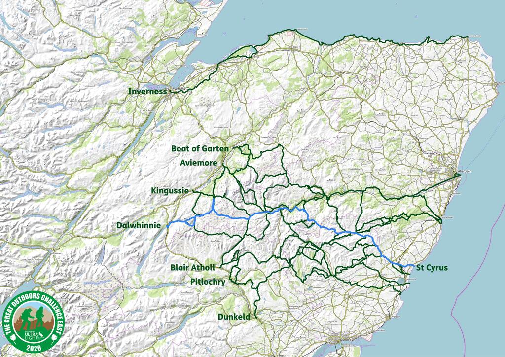
Route 3 – Boat of Garten to St Cyrus – Grade 2
Duration: 7 days Total Distance: 161km Total ascent: 2560m
Average day: 23km & 375m ascent
Start Days: Thursday 14th May to Saturday 16th May

This is a mainly low-level route, following established paths and tracks with straightforward navigation; however, it certainly starts with a bang! Taking you through some glorious scenery past Bynack More, along Glen Avon, Loch Builg and on to Ballater, you will need to carry 3-days of supplies with you. Out of Ballater, it’s a shorter day to Aboyne on the Deeside Way, followed by a more testing, but stunning, day over the Fungle Road to the social centre of the Challenge at Tarfside. Then it’s 2 days of tracks and minor roads to the coast to end your adventure.
Terrain: Manageable daily distances on paths/tracks/ with some road walking in last few days.
Toughest days: Day 1 is the toughest day with a distance of 27km and an overall ascent of 900m, but it is followed by some more gentle days.
Highlights:
- A view of Bynack More – maybe you can come back and bag it another time?
- Glen Avon and Glen Builg are beautiful walks.
- Overnight halts at Ballater and Tarfside – two of the social hubs of the Challenge.
- The classic finish of St Cyrus with your final big ascent – you’ll see…
Resupply options:
- Ballater.
- Aboyne.
Accommodation: Mainly camping or wild camping, with options in Ballater and Aboyne to find some more formal accommodation.
Sociability: You quickly join some of the classic TGOC routes of the Challenge, so will no doubt encounter others on your travels. Ballater and Tarfside are very popular stopping points along the way to eat, drink, chat and make merry!
Aviemore
A ski resort in winter and a bustling outdoor focused village all year round. Plenty of places to sleep and eat before you set out, and several outdoor shops for those forgotten items.
Route 4 – Aviemore to Stonehaven – Grade 2
Duration: 8 days Total Distance: 162km Total ascent: 3840m
Average day: 23km & 550m ascent
Start Days: Thursday 14th May to Friday 15th May

A great departure out of Aviemore on a spectacular walk with wild/bothy camping over the first 3 nights past Bynack More, through Glen Avon and into Ballater. Day 5 is a long, high, but great day (have an early start!) to Tarfside taking in Mount Keen (Munro) and ending with a sociable evening in Tarfside chatting with other Challengers. Another high day follows over Mount Battock (Corbet) and staying in/around Charr Bothy. Next is a forest walk with a wild camp in the Fetteresso Forest and short, final day into Stonehaven, allowing you plenty of time to get to Montrose to finish the event and join in one of the renowned Challenge Dinners.
Terrain: Quite a demanding walk, with 2 Munros. Mainly on good paths and tracks as well as a short bit (1km or so) of off-piste heather bashing, so be careful with your navigation.
Toughest days: Days 5 is the toughest day (28km distance and 1150m ascent) bagging Mount Keen, with Day 6 a close second (21km and 810) bagging Mount Battock. FWAs are available…
Highlights:
- A first -night, bothy night at Ryvoan.
- The walk through Glen Avon and Glen Builg is beautiful.
- If you’ve not bagged a Munro before, Mount Keen is one of the more straightforward tops.
- Tarfside, Mount Battock and the Fetteresso Forest – great days out, in fine weather!
- If you have time (and the energy) when you finish, pop down to view Dunnottar Castle.
Resupply options:
- Aviemore has all the amenities that you will need – but remember to cater for 4 days/3 nights from the off.
- Ballater also has excellent services and shops etc. – once again remember to cater for 4 days/3 nights to take you to the end.
Accommodation: It’s mainly wild camping/bothies on this route; however, Ballater has a great campsite, as well B&Bs, a hostel and hotels for a night of luxury (plus the odd pub!).
Sociability: This is a popular route with those on the main TGO Challenge, so you will probably have plenty of opportunities to chat and walk with others.
Route 5 – Aviemore to Kinnaber Links- Grade 3
Duration: 8 days Total Distance: 135km (155km FWA) Total ascent: 2490m (2090m FWA)
Average day: 19km (19km FWA) & 356m (260m FWA) ascent
Start Days: Thursday 14th May to Friday 15th May (see comment * below)

Another great 8-day route (includes a rest day if FWA isn’t needed) out of Aviemore taking in the high pass that is the Lairig Ghru as you make your way to Braemar. From there, it’s a classic Challenge route through the Spittal of Glen Muick and on to Tarfside. Then a low-level route to the finish at Kinnaber links – a great finish point. Night stops include Corrour bothy, Braemar, Gelder Shiel bothy, Shielin of Mark bothy and Tarfside.
If the weather is against you and the Lairig Ghru is not advisable (often due to high winds, but deep snow and heavy rain have featured in the not too distant past), then it’ll be a longer (8-day) Foul Weather Alternative (FWA), but beautiful route through Glen Feshie to Braemar, with options to stay at Ruigh Aiteachain and Ruighe Ealasaid (The Red House) bothies enroute.
* This route is designed to be easy going in terms of daily distance, but it can be flexible if you wish to combine days and complete the walk in a shorter, 6/7-day duration, which means that a Saturday 16th May start is also a possibility – just have a chat with the Coordinators for details.
Terrain: Mainly on good paths and tracks (and a boulder field crossing) with a good test of navigation on the day to the Shielin of Mark.
Toughest days: No particularly difficult days other than the first day (23km with 685m of ascent) through the Lairig Ghru – especially if there is a strong wind.
Highlights:
- The Lairig Ghru is quite spectacular.
- Several bothy opportunities.
- The social gatherings at Braemar and Tarfside.
- Strawberry tarts to finish! Mmmmm!
Resupply options:
- Other than Aviemore, Braemar is the only real re-supply point, with a store and outdoor shop.
- Late in the (last) day, you can always gorge on strawberry tarts at the Charleton Fruit Farm!
Accommodation: Mainly bothy or wild camping, but Braemar offers hotels, bunkhouse, hostel, B&B and campsite accommodation.
Sociability: Very social on this classic TGO Challenge route.
Route 6 – Aviemore to Dunnottar Castle via Ben Macdui- Grade 4
Duration: 8* days Total Distance: 157 (165) km Total ascent: 4,500 (2,910) m
Average day: 22 (20)km & 640 (365)m ascent
Start Days: Thu 14th May to Fri 15th May
This is a demanding, high-level route that takes in tops in the Cairngorms, Jock’s Road, the ridge above Glen Clova and Mount Battock above Glen Esk. It is mainly on good paths and tracks but some careful navigation is needed on the tops, particularly in poor weather, and as the paths shown on the map are sometimes not in evidence on the ground.
This route is assessed as being a Grade 4 and starts, from the off, with a long, hard day with a lot of ascent that takes you over Ben Macdui – we recommend an early start! We’ve then included a rest day in Braemar (to synchronise accommodation bookings if you have to take the FWA from Aviemore) before a couple of high, hard days over to Glen Clova and then on to Tarfside. Sticking with the theme, it’s taking the high ground to the north of Glen Esk via Mount Battock into the Fetteresso Forest and a finish in at Dunnottar Castle.
*In adverse weather the high days are not advisable, therefore Foul Weather Alternatives are provided. The Main route takes 7 days; however, the FWA out of Aviemore adds a day to the overall schedule, hence the 8-day duration. The distance and ascent figures shown in brackets are for the FWA route.
Terrain: The route uses tracks and paths where possible, but path sections of Jock’s Road can be vague and the FWA out of Clova requires careful navigation as the for a coupe of pathless kms.
Toughest days: The first day over Ben Macdui and the third day over Jock’s Road to Clova are the toughest each with around 1100m of elevation gain.
Highlights:
- Ben Macdui early in the morning on a clear day!
- Enjoy the Braemar and Tarfside Gatherings.
- Bagging a few tops.
Resupply options:
- Braemar has a general store and an outdoor shop as well.
- Resupply parcels can be sent to Mar Lodge and/or Braemar to be picked up enroute. See here for details.
- If staying at the Glen Clova hotel, then resupply parcels can be sent there to be collected on arrival but please confirm this directly with the hotel.
Accommodation: Whilst not wild camping, there are bothies, camping at Braemar and Tarfside, as well as more formal accommodation in Braemar and Clova.
Sociability: As well as being demanding, this a very social route with Braemar, Lochallater, Clova and Tarfside being high on the list of Challenge favourites.
Route 7 – Aviemore to Kinnaber Links – Grade 1
Duration: 7 days Total Distance: 154km Total ascent: 2134m
Average day: 22km & 305m ascent
Start Days: Thu 14th May to Sat16th May

This is a low level, delightful route, through woodland, along Glen Feshie, Geldie Burn and into Braemar. Then it’s on to Tarfside via Ballochbuie Forest, Glen Muick and Glen Lee, with a finish at Kinnaber Links. Nearly all on paths other than a short pathless section into and out of Shielin of Mark. If you wish to test your navigation skills, you can opt for a straight line approach to Shielin of Mark from the head of the Allt Darrarie and see how close you can get!
This route is assessed as being a Grade 1; however, the day out of Braemar is long and has quite a bit of ascent -so be warned! Why not view this day to challenge your comfort zone: it is a Challenge after all.
Terrain: It’s good tracks and paths all the way, other than a bit into and out of Shielin of Mark bothy.
Toughest days: Day 4 from Ballater to Shielin of Mark is 29kms with 880m of ascent – you’ll love it!
Highlights:
- The bothies and the glens.
- The Braemar and Tarfside Gatherings.
- The strawberry tarts at Charleton Fruit Farm on the last day… Mmmmm!
Resupply options:
- General store and outdoor shop in Braemar.
- Mar Lodge and Braemar campsite will hold resupply parcels for you. See here for details.
Accommodation: Mainly bothy or wild camping, but Braemar offers hotels, bunkhouse, hostel, B&B and campsite accommodation.
Sociability: Very social on this classic TGO Challenge route.
Kingussie
Kingussie is a small town just off the A9 with a train station, shops, hotels, and B&Bs etc. It sits inside the Cairngorm National Park and has great access routes to the hills to the East and to the West. It is handily placed on the Speyside Way long distance path and is an oft-used staging place for many on the TGO Challenge.
Route 8 – Kingussie to Aberdeen- Grade 1
Duration: 8 days Total Distance: 165km Total ascent: 1570m
Average day: 21km & 200m ascent
Start Days: Thu 14th May to Fri15th May

Starting at Kingussie, the route makes us of good tracks and paths over to Glen Feshie and then south to Ruigh aiteachain bothy. From there it’s on to Ballater via Linn of Dee, Invercauld, Ballochbuie Forest and Balmoral. Leaving Ballater, it’s a waymarked route all the way into Aberdeen via the Deeside Way, with plenty of places to stop, rest, eat and drink, ending at Girdle Ness Lighthouse.
This is planned as an 8-day route, to keep the daily distances down, so needs to be started by Friday 15th May at the latest; however, there is scope to do the Deeside Way in 3 days (the plan does it in 4 days), so a start date of Sat 16th May is possible by doing some slightly longer days at the end. If this appeals to you just let the Coordinators know and we’ll work something out with you.
Terrain: This route is a low-level walk on good paths, tracks, waymarked trails and paved surfaces.
Toughest days: Day 2 has both the greatest distance and ascent at 28km and 360m respectively, following the River Feshie, Geldie Burn and the River Dee: it’s great day’s walk.
Highlights:
- Glen Feshie is a beautiful walk with stunning views.
- Ballater is a very popular staging post for Challengers with good facilites.
- The Deeside Way is well signed, ahs plentiful opportunities to rest and recuperate and takes you all way into Aberdeen.
Resupply options:
- Before you start there’s a good store in Kingussie.
- Ballater has shops and stores, but there is the option to divert into Braemar for an emergency full-cooked breakfast!
- Many stores in the villages and towns along the Deeside Way.
Accommodation: A mixture of bothie and wild camping, with campsites, and more formal accommodation from Ballater onwards.
Sociability: Kingussie is a very popular staging post for those on TGO Challenge with Glen Feshie also a major draw for those who prefer a lower-level route. Ballater is also very popular, and many Challengers use at least some of the Deeside Way to get to the coast.
Route 9 – Kingussie to Kinnaber Links via Lochnagar – Grade 2
Duration: 8 days Total Distance: 162 (156) km Total ascent: 2800 (2320)m
Average day: 20 (19)km & 350 (290)m ascent
Start Days: Thu 14th May to Fri15th May

This route is a grade 2 level of difficulty, but is also a real bothy-fest! Out of Kingussie, it takes in bothies along Glen Feshie and Geldie Burn, with a night stop at Braemar (with potentially another bothy stop Lochallater Lodge instead). Then it’s a great, high day, over Lochnagar to bag some Munros before descending to stay at the Glass Allt Shiel bothy. From here you join the TGOC classic route to Tarfside via the Shielin of Mark bothy, popping over Muckle Cairn into Glen Lee and on to the social centre of the Challenge at Tarfside. The final couple of days are riverside and road walks to North Water Bridge, ending at the very popular Kinnaber Links
As there is a high day out of Braemar involved, the route provides a Foul Weather Alternative (distance and ascent shown above in brackets) if the conditions are unsuitable, which stays low-level, and takes in the Gelder Shiel bothy.
Start Days
This an 8-day crossing so has to be started by Friday, 15th May at the latest. If you have the flexibility to start on Thursday, 14th May, then you could include a rest day, split a couple of days or just finish on Thursday 21st May to welcome in other Challengers as they arrive in Montrose.
Terrain: generally on good tracks and paths, with some short pathless sections into and out of Shielin of Mark bothy.
Toughest days: The day over Lochnagar is the toughest with a walk of 26km and 1100m of ascent; however, it is followed by a short day where you can start late and still finish early.
Highlights:
- Definitely Lochnagar – keep your fingers crossed for good weather!
- The many bothies along the way.
- The social gatherings at Braemar and Tarfside.
- Strawberry tarts on the last day… Mmmm.
Resupply options:
- Before you start there’s a good store in Kingussie.
- Braemar has a store as well as an outdoor shop.
Accommodation: Other than Braemar, where there are many options: hotels, bunkhouse, B&B, youth Hostel and campsite, this is a route that provides a good outdoor experience to wild camp and use bothies.
Sociability: A very sociable route, which is popular with many Challengers – be careful not to get stuck in the time warp of Braemar.
Route 10 – Kingussie to Aberdeen via Glen Tromie – Grade 2
Duration: 8 days Total Distance: 170 (172)km Total ascent: 1765 (1655)m
Average day: 21 (22)km & 220 (207)m ascent
Start Days: Thu 14th May to Fri15th May.
Starting at Kingussie it’s along the beautiful Glen Tromie and on to Glen Feshie. You’ll need to be confident of fording rivers as there is a crossing of the River Feshie, but in normal conditions, it’s quite an easy crossing. If the river’s too high then there’s an additional 10km added on to the next day but this can be spread over the following 3 days. Then it’s on to Ballater via Linn of Dee, Invercauld, Ballochbuie Forest and Balmoral. From Ballater, it’s a waymarked route all the way into Aberdeen via the Deeside Way, with plenty of places to stop, rest, eat and drink, ending at Girdle Ness Lighthouse.
Start Days: This is an 8-day route so needs to be started by Friday 15th May at the latest; however, there is scope to do the Deeside Way in 3 days (the plan does it in 4 days), so a start date of Sat 16th May is possible by doing some longer days at the end. If this appeals to you just let the Coordinators know and we’ll work something out with you.
Terrain: This route is a low-level walk on good paths, tracks, waymarked trails and paved surfaces. There is a fording of the River Feshie to be done, which is usually very straightforward, but we strongly recommend that participants check the weather forecast to make sure that the weather is suitable for the river crossings. If the rivers are running high, there is a FWA straight from the off that entirely avoids the crossing of the River Feshie.
Toughest days: Most days are quite straightforward with no major ascents; however, if you’re on your main route and find that you cannot cross the River Feshie then the additional 10km will need to be recovered over the following 2-3 days into Ballater.
Highlights:
- The wilderness of Glen Tromie.
- The fording of the River Feshie!
- Ballater is a firm favourite as a stopping place for Challengers.
- The easy going of the Deeside Way.
Resupply options:
- Before you start there’s a good store in Kingussie.
- Ballater has shops and stores, but there is the option to divert into Braemar for an emergency full-cooked breakfast!
- Many stores in the villages and towns along the Deeside Way.
Accommodation: A mixture of bothy and wild camping, with campsites, and more formal accommodation from Ballater onwards.
Sociability: Kingussie is a very popular staging post for those on TGO Challenge with Glen Feshie also a major draw for those who prefer a lower-level route. Ballater is also very popular, and many Challengers use at least some of the Deeside Way to get to the coast.
Route 11 – Kingussie to Dunnottar Castle via Ben A’an – Grade 4
Duration: 8 days Total Distance: 182km Total ascent: 5500m
Average day: 25km & 700m ascent (excluding half days)
Start Days: Thu 14th May or Fri 15th May.
This is a tough route with long days and significant ascent seeking out remote places and high ground including 7 summits (6 Munros and 1 Corbett) taking you up to 1171m at it’s highest point. But when in the glens it is in popular Challenge territory making it a sociable route as well.
Starting with a visit to Glen Feshie it takes you up onto a high plateau for a first night high camp if the weather allows. The route visits the Linn of Dee and Mar Lodge but eskews Braemar in favour of the magnificent massive of Ben Aan and it impressive summit tor before descending to Ballater. A long day to Tarfside is followed by 3 slightly easier days over Mount Battock and through the Fetteresso forest allowing you make the most of Tarfside’s hospitality, a possible finally high camp and time to enjoy the spectacular finish at Dunnottar Castle and the delights of Stonehaven. These last three days can be done in two long days if you prefer.
Terrain: There is quite a bit of pathless terrain often at altitude so your navigational skills are likely to be tested. Although there is some rough terrain we have graded as 4 largely because of the long days with some big ascents.
Highlights:
- View from Sgor Gaoith into Gleann Einich and a high camp
- Linn of Dee and Mar Lodge
- Ben A’an
- Mounth Road over Mount Keen
- Welcome at St Drostan’s, Tarfside
- Dunnottar Castle
Resupply options:
- Before you start there’s a good store in Kingussie.
- Ballater has food shops including some independents, a chemist and a branch of Braemar Mountain Sports for dried food, gas and gear
- Tarfside offer light refreshments but no meals and they cannot take resupply parcels
Accommodation: A range of accommodation in Ballater including the excellent Ballater Hostel and Ballater Caravan Park which both regularly welcome Challengers. Beds are available at St Drostan’s Hostel on the day but cannot be pre-booked.
Sociability: Kingussie is a very popular staging post for those on TGO Challenge with Glen Feshie also a major draw Ballater is also very popular and the legendary welcome at Tarfside attracts over half of Challengers.
Dalwhinnie
The very small village of Dalwhinnie is our highest start point at 360m above sea level. It has a remote feel despite being close to the A9 and on the Perth to Inverness Highland rail line. There are no shops and often no where to eat in the evening so you need to bring all you supplies with you. There is no easy way to go east from Dalwhinnie so no grade 1 routes start here.
Route 12 – Dalwhinnie to St Cyrus via Glen Feshie & Braemar – Grade 2
Duration: 8 days Total Distance: 165km Total ascent: 2500m
Average day: 21 km & 350m ascent
Start Days: Thu 14th May or Fri 15th May
This route is based on route 13 but takes it’s FWA from Braemar significantly reducing the ascent and time on pathless ground.
You are very soon into remote territory, with at times pathless terrain, but also making use of an impressively constructed stalker’s path with spectacular views. Next you join a more frequented Challenger route, though beautiful Glen Feshie. Easy days into an out of Braemar give a chance to relax before a tougher few days bring you to Tarfside and a beautiful walk along the River North Esk towards the Coast.
Although this route doesn’t seek out summits as it involves some high ground and unbridged rivers FWAs are needed for several days we have given it a grade 3. Should you be finding the going hard at Braemar the FWA from there offers you shorter days with less ascent and would make it a grade 2 route.
Terrain: We have graded this as a 2 as it is technically a lower level route, not seeking out any summits, but it is at the more difficult end of this range. It takes you over 700m on two occasions even on FWAs. There are unbridged burn/river crossings with one major one which may require a 10km diversion if you are unlucky enough to find it in spate. It also includes up to 3km stretches on pathless terrain, including some peat hags, which will be slow going particularly when wet.
Toughest days: Although not the longest or the highest, Day 1 includes some rough and relatively high ground making it one of the tougher days on this route. The most ascent in a day is 700m and also includes some pathless ground in its 22km. The longest day is 27km but is on easy generally flat ground and be in the company of others.
Highlights:
- Stalkers path to Gaick
- Rewilded Glen Feshie
- Up to 4 MBA bothies
- The delights of Braemar (cafes a chance to restock and relax)
- Historic Jock’s Road
- Warm Challenger welcome and home baking at Tarfside (you have to experience it to get it!)
- A Charlton Farm Strawberry Tart just before you finish.
Resupply options:
- Braemar – a small supermarket, butchers and a good Outdoors shop which sells gas canisters.
Accommodation: Opportunities to wild camp on 6 nights with campsites available for the remaining 2 nights. MBA bothies available for 2 nights (more on FWA) B&Bs and hostels available in Braemar (and a hotel if you have a very large budget!) and at Clova
Sociability: This route will give you the full TGOC camaraderie experience – one of the aspects of the Event that brings people back year after year. You may be walking by yourself for the first day or so but after that you are on popular Challenge routes and likely to be come across plenty of folk on the main event.
Route 13 – Dalwhinnie to Kinnaber Links via Glen Feshie & Jocks Road- Grade 3
Duration: 8 days Total Distance: 165km Total ascent: 2500m
Average day: 23km & 350m ascent
Start Days: Thu 14th May or Fri 15th May

You are very soon into remote territory, with at times pathless terrain, but also making use of an impressively constructed stalker’s path with spectacular views. Next you join a more frequented Challenger route, though beautiful Glen Feshie. Easy days into an out of Braemar give a chance to relax before a tough but rewarding couple of days including historic Jock’s Road bring you to a warm welcome at Tarfside and a beautiful walk along the River North Esk towards the Coast.
Although this route doesn’t seek out summits as it involves some high ground and unbridged rivers FWAs are needed for several days we have given it a grade 3. Should you be finding the going hard at Braemar the FWA from there offers you shorter days with less ascent and would make it a grade 2 route.
Terrain: We have graded this as a 2 as it is technically a lower level route as it does not seek out any summits but it is at the more difficult end of this range. It takes you over 700m several times and therefore includes significant ascent. There are several unbridged burn/river crossings with one major one which may require a 10km diversion if you are unlucky enough to find it in spate. It also includes up to 3km stretches on pathless terrain, including some peat hags, which will be slow going particularly when wet.
Toughest days: Although not the longest day or the highest, Day 1 includes some rough and relatively high ground making it one of the tougher days on this route. The most ascent in a day is 700m and also includes some pathless ground in its 22km. The longest day is 27km but is on easy generally flat ground and be in the company of others.
Highlights:
- Stalkers path to Gaick
- Rewilded Glen Feshie
- Up to 4 MBA bothies
- The delights of Braemar (cafes a chance to restock and relax)
- Historic Jock’s Road
- Warm Challenger welcome and home baking at Tarfside (you have to experience it to get it!)
- A Charlton Farm Strawberry Tart just before you finish.
Resupply options:
- Braemar – a small supermarket, butchers and a good Outdoors shop which sells gas canisters.
- Clova – if staying there you can send yourself a resupply parcel
Accommodation: Opportunities to wild camp on 6 nights with campsites available for the remaining 2 nights. MBA bothies available for 2 nights (more on FWA) B&Bs and hostels available in Braemar (and a hotel if you have a very large budget!) and at Clova
Sociability: This route will give you the full TGOC camaraderie experience – one of the aspects of the Event that brings people back year after year. You may be walking by yourself for the first day or so but after that you are on popular Challenge routes and likely to be come across plenty of folk on the main event.
Route 14 – Dalwhinnie to Dunnottar Castle via Tarf Water & Jocks Road – Grade 4
Duration: 8 days Total Distance: 195km Total ascent: 4300m
Average day: 24.5km & 530m ascent
Start Days: Thu 14th May or Fri 15th May

Up for a Challenge? This is the toughest and longest route we have on offer – and yet, in a rather gloriously perverse way, it doesn’t go over any summits! Instead it sticks to truly remote often pathless country, wild camping every night and taking you through some stunning places that few people will ever visit. It’s one for the backpacking purest in search of solitude and a wild place to lay their head.
From Dalwhinnie the route takes you along some amazingly constructed and infrequently used stalkers path then follows the pathless but stunning River Tarf to one of the MBAs most remote bothies – the “Tarf Hotel”. You then pass by one of the remotest farms in mainland Scotland before a chance to stock up and have lunch as you pass through Braemar. From there you will meet a few more Challengers but the route continues to seek out wild country including historic Jocks Road until you reach magnificent Dunnottar Castle.
We have given you 8 days for this route, but the beauty of a pure wild camp route is the option to push on when you are feeling good and it could be completed by an exceptionally strong backpacker in 7 days – but they would be very long days.
Terrain: Its tough going right from the start! You will traverse a lot of rough and pathless ground and have your share of tussles with peat bogs and several large burns to ford. Even the sections which coincide with regular Challengers routes still contain pathless sections.
Toughest days: There are no easy ones. The 20km and 380m of ascent on the second day looks easy on paper but you may well find it the hardest day of the route. The longest day is 27km and 770m ascent but may seem a fair bit easier!
Highlights:
- All of it – you are rarely somewhere unimpressive!
- Allt Garbh Gaick stalkers path
- River Tarf and the “Tarf Hotel”
- Lunch in Braemar and a couple of places offering warm welcomes to Challengers and Challenge Easters.
- Historic Jocks Road
- You deserve the most spectacular of Challenge finish points – Dunnottar Castle
Resupply options:
- Braemar – a small supermarket, butchers and a good Outdoors shop which sells gas canisters.
- Tarfside – home baking and hot drinks on offer but no resupply opportunities.
Accommodation: Wild camping all the way but pushing on in the first few days could allow a B&B or campsite stop in Braemar and a half day out of it.
Sociability: You are very likely to be alone until you get to Braemar. From there you are more likely to meet Challengers and you may well get to share your finish.
Blair Atholl
Blair Atholl is a small village with a train station, hotels, B&Bs and a campsite. It has an impressive castle and a working watermill with an excellent café. So well worth exploring for a day before you start walking.
Route 15 – Blair Atholl to Aberdeen via Deeside Way – Grade 2 (Grade 1 if FWA not needed)
Duration: 7 days Total Distance: 145km Total ascent: 1400m
Average day: 21km & 200m ascent
Start Days: Thu 14th May to Sat 16th May

A low-level route with generally low levels of daily ascent. It starts in remote country travelling through a steep sided glen then picks up Scotland’s fastest flowing river – the Dee. From Ballater it takes the Deeside Way through more pastural landscapes to the city of Aberdeen and the North Sea finishing at the hidden gem of Footdee.
If you don’t like too much ascent and enjoy a café or two or a comfy bed this may be the route for you as it passes through several villages allowing regular resupplies and opportunities to use B&Bs and hotels if you wish.
All but one day would be considered a grade 1 route but the potential sting in its tail is the fording of the River Geldie. Normally it’s no more than an ankle deep paddle but if impassable the diversion is pathless for 4km on rough ground. After that there are bridges across even minor burns.
Terrain: All on good paths and tracks all the way – unless the River Geldie is unfordable. Waymarks from Ballater onwards.
Toughest days: The longest day is 27km but largely on flat ground and good paths and there is an opportunity to shorten it and take an extra day . The roughest section underfoot is the beginning of day 2 where you are on a rough path – and if the Geldie is not crossable you will have 4km of tough pathless walking.
Highlights:
- Glen Tilt, Falls of Tarf and the Bedford Bridge
- A café every day from Braemar!
- Poignant Prince Albert’s Cairn
- Balmoral Castle, café and distillery
- The River Dee and Polhollich and Cambus o’May bridges
- Footdee – fishing village in the heart of Aberdeen
Resupply options:
- A small shop in Blair Atholl before you start and excellent bread from the Watermill.
- From Braemar onward there is the chance to resupply almost daily inlocal shops and supermarkets
- Braemar, Ballater and Banchory have chemists. and outdoor shops
Accommodation: There is the opportunity to camp most nights either wild camping or on a commercial campsite. Wild camping on the Deeside Way can be tricky as you are in more populated and pastoral areas – pre booked accommodation may be easier. Plenty of B&B and hotel options in Braemar, Ballater, Aboyne, Banchory and Aberdeen.
Sociability: The route as far as Ballater is popular with Challengers. The Deeside Way beyond Aboyne is less well used but you are still likely to meet a few along the way.
Route 16 – Blair Atholl to Kinnaber Links- Grade 2
Duration: 6 days Total Distance: 138km Total ascent: 3400m
Average day: 25km & 370m ascent
Start Days: Thu 14th May to Sun 17th May

This route follows popular TGO Challenge lines through remote glens and up an iconic Scottish mountain.
The first few days are on easy ground through an impressively steep-sided glen bringing you into one of the Challenge hotspots – Braemar – where you can enjoy the cafes and bars and swap stories with those on the main Event. It involves fording a river – barely above the ankles in normal conditions but a pathless and rough FWA if it is in spate.
From Braemar you climb Lochnagar with its fine tor like top and magnificent views into its dark and deep corrie. If the weather is less than perfect the FWA is a grand walk in its own right taking you through natural pine forests on the Balmoral Estate. You then head to Tarfside – a little bit of pathless ground here for 2km – where a warm welcome awaits you and then its a walk along Glen Esk to the Coast.
Some days are relatively long but you can add in a rest day at Braemar or take an extra day between Braemar and Tarfside.
Terrain: Generally good paths and tracks. A short pathless sections on rough ground requiring good navigation in poor visibility and potential some pathless ground on one FWA.
Toughest days: 25km and 1050m of ascent on the Lochnagar day but the FWA is shorter and lower. Longest day is 27km but on largely flat ground.
Highlights:
- Glen Tilt, Falls of Tarf and the Bedford Bridge
- Fording Glen Geldie ( the FWA may be a lowlight if in spate . . . )
- Braemar – cafes, shops and Challenger company
- Lochnagar
- 3 MBA bothies for a sheltered lunch
- A warm Challenger welcome and home- baking at Tarfside
- Beautiful Glen Esk and the Blue Door Walk through the Rocks of Solitude
- A Charlton Farm Strawberry Tart and a stunning sandy beach to finish
Resupply options:
- Mar Lodge – will hold Challengers resupply parcels.
- Braemar – cafes, shops, a good butchers, chemist and outdoor shop (gear, gas and dried food).
- Tarfside – excellent home baking and maybe a bacon/egg roll but no supplies available so you need to cater for youself.
Accommodation: Braemar has a campsite, 2 hostels, B&Bs and, if your budget will stretch, one very exclusive hotel. All (including the campsite) need to be prebooked as accommodation can be hard to find on the day. Otherwise it is camping all the way with several wild camps, a chance to camp on the village playing field in Tarfside and a campsite for your final night.
Sociability: This is a very sociable route. You are likely to meet plenty of Challengers along the way as well as in Mar Lodge stables, Braemar Cafes, in St Drostan’s kitchen and at North Water Bridge Dovecot campsite.
Route 17 – Blair Atholl to Stonehaven via Clova – Grade 3
Duration: 7 days Total Distance: 145km Total ascent: 1400m
Average day: 21km & 800m ascent
Start Days: Thu 14th May to Sat 16th May
This route is a demanding route taking in 7 summits (4 Munros and 2 Corbetts) whilst also visiting some remote and beautiful glens. Whilst much of it follows paths and tracks there are some sections which are pathless that will require good navigational skills, especially in poor visibility. It has several FWAs some of which also involve pathless high ground at 600-800m.
The route warms you up with the long ridge of Beinn a’Ghlo before taking you through a beautiful and remote glen to a wild camp by a high loch. You are now going across the grain of the high plateaux that are a feature of the eastern hills, dropping to Clova with it’s hotel. From here you are on a regular Challenger route but don’t be deceived – the path is rarely walked except for a few days in May so the path is faint or non existent in places. A stop at Tarfside allows you to enjoy some home baking and swop tales with other Challengers before a final hill and a walk through the Fetteresso Forrest to the atmospheric old harbour at Stonehaven.
Resupply opportunities are limited – there are no shops enroute so you will need to stay a night in a hotel and/or arrange to send yourself a parcel there. An extra day could be added to this route to allow a stop in Spittal of Glenshee.
Terrain: Mostly on tracks and paths but some stretches of pathless, rough and heathery ground. Minimal road walking – just 10km mainly on the last day. There are no major unbridged rivers but there are several fords of side burns which will require care and suitable skills if in spate.
Toughest days: The day into Clova is the longest at 27km and involves 2 Munros and some pathless ground. There is an opportunity to avoid the second Munro and pathless ground but it remains a long day with an FWA that although lower is almost as tough as the main route.
The most ascent (1300m) is on Day 1 but if you want a gentler warm up the FWA is a relatively easy stroll.
Highlights:
- Beinn a’Ghlo (and for the baggers 4 Munros and 2 Corbetts in total)
- Loch Beanie camp
- Clova Hotel – feels like an oasis in the wilderness!
- Tarfside – a warm welcome and home baking
- Clachnaben – impressive rocky tor and a view of the sea
- Stonehaven harbour, excellent bars and seafood restaurant – and don’t forget to pick up an Italian ice-cream from Giulianotti’s!
Resupply options: Your options are limited as there are no shops along the way. Your route stops at Clova on Day 3 which will hold resupply parcels for Challengers staying there. They may hold a parcel if you are coming in for a drink or a meal – but you must ask first.
Accommodation: Wild camping all the way except for the option of a hotel bed in Clova. The Dalmunzie Castle Hotel and Gulabin House at Spittal of Glenshee may also be accommodation options but will require an extra day to be added to the route for all but the super fit.
Sociability: You might encounter a few Challengers in the first few days but from the bar at the Clova Hotel onwards you are likely to come across a lot more. Nearly half of Challengers go through Tarfside so you will have a chance to swap stories there and the route to Stonehaven is also popular.
Pitlochry
A large village with plenty of shops, cafes and places to stay. It also has a theatre so worth checking on what’s on the night before you start.
Route 18 – Pitlochry to Lunan Bay – Grade 1
Duration: 6 days Total Distance: 125km Total ascent: 2100m
Average day: 23km (excluding half day) & 350m ascent
Start Days: Thu 14th May to Sun 15th May
A lower level route, with relatively low distances and ascents, winding through less frequented glens and the softer southern edge of the Highlands before crossing the Angus plains to Lunan Bay. it passes through an array of varied landscapes. It is surprisingly remote route, passing through only one village with a shop and another hamlet with a hotel. It is designed as a “wild camping all the way” route but the schedule could be adjusted by using some half days to include one or two hotel stops. Resupply opportunities are limited and you will need to carry at least 4 days of food with you.
A short half day to start allowing you to arrive in the morning or explore Pitlochry. Possibly take in a distillery tour and carry a nip for your first camp by a beautiful loch. Moorland studded with lochans take you onto the Cateran trail then you pass through a gem of a “glen in miniature”. You then skirt the southern edge of the hills before striking across to the Coast. The last few days include some road walking on country lanes. It is generally easy walking but there are some faint paths on rough grounds making it the top end of a grade 1.
Terrain: Almost all on paths or tracks but occasionally faint or overgrown with occasional rougher ground. Some walking on minor roads.
Toughest days: Longest day is 26km and 390m ascent
Highlights:
- Blackspout waterfall
- Loch Broom camp
- Craig of Balloch
- Drovers Inn, Memum
- Aberlemno Pictish stones
- Lunan Bay
Resupply options: Options are very limited on this route so you will need to carry food for much of the journey with you. There are opportunities to alter the schedule to allow a hotel stop (and resupply parcel to Kirktown of Glenisla
- Kirkmichael – village shop and café
- Kirkton of Glenisla has a hotel, usually open for lunches, which may allow you to send a parcel – please ask first and check opening hours/days for availability of food.
- Finavon – Peggy Scott’s café
Accommodation: Wild camping all the way but a long first day or some half days would allw hotel stops in Kirkmichael and/or Kirktown of GlenIsla
Sociability: You may find a few discerning Challengers along this route but most of it is relatively unfrequented. If you eschew the crowds this one’s for you.
Route 19 – Pitlochry to Kinnaber Links – Grade 2
Duration: 7 days Total Distance: 110km Total ascent: 2600m
Average day: 22km & 375m ascent (excluding half days)
Start Days: Thu 14th May to Sat 16th May

A lower level route, with relatively low distances and ascents, winding through less frequented glens and over a few lower hills in the second half. It’s not a popular Challenge route but it really should be as it goes through some wonderfully varied landscapes.
You start with a half day allowing you to arrive in the morning or explore Pitlochry. Possibly take in a distillery tour and carry a nip for your first camp by a beautiful loch. Moorland studded with lochans take you onto the Cateran trail for a few miles then you pass through a gem of a “glen in miniature” with an option hill for a fine view if the weather allows. You then skirt the southern edge of the hills ascending a few for excellent views over the Angus plain before joining a popular Challengers route for the final day to the Coast.
It is generally easy walking but is graded 2 because of some faint paths on rough ground and one deer fence on an FWA that needs climbing. However the fence can be avoided by walking on minor roads.
The schedule given involves 2 half days. A longer first day would allow it to be completed in 6 days and would allow some B&Bs and hotels to be used.
Terrain: Generally good paths, tracks and some minor roads Some are indistinct so reasonable navigational skill are require. It involves walking on quiet minor roads for significant sections of the last few days.
Toughest days: Longest day is 25km and the most ascent in a day is 720m though an FWA is available.
Highlights:
- Blackspout waterfall
- Wildcamp by Loch Broom
- Craig of Balloch
- Catertun hill forts (6km diversion) and Edzell Castle (FWA)
- A sociable finish with a Charlton Farm Strawberry Tart
Resupply options: Options are limited so you may need to carry 4 or 5 days of food
- Kirkmichael has a village shop
- Kirkton of Glenisla has a hotel, usually open for lunches, which may allow you to send a parcel – please ask first and check opening hours/days for availability of food.
- Edzell has a shop and cafes but is a 4km diversion (unless it suspension bridge is repaired by May)
Accommodation: The schedule given involves wild camping for most nights and 1 campsite. However a long first day (or adding an extra day) could allow use of hotels at Kirkmichael, Kirktown of Glenisla and Edzell
Sociability: You may find a few discerning Challengers along this route but most of it is relatively unfrequented. If you eschew the crowds this one’s for you.
Route 20 – Pitlochry to Scurdie Ness – Grade 2
Duration: 6 days Total Distance: 140km Total ascent: 2500m
Average day: 23km & 400m ascent
Start Days: Thu 14th May to Sun 17th May

A generally lower level route through glens with occasional excursions onto higher ground – one of which cannot be easily avoided. It give a good mix of remote glens and more pastoral scenery as you approach the coast. There may be occasional deer fences to deal with and some short pathless sections.
Starting in the beautiful wooded deep gorge of the River Garry you are soon out into open moorland with a truly remote feel. A succession of passes mean you will be going up and down a fair bit with a high point of just under 800m before you descend into Glen Prosen. From there you have a fine ridge walk to the Airlie Monument for a view over the Angus plain. You then weave a way along the edge of the hills before striking across the plain to Brechin then follow the river to the Montrose Basin and a chance for a spot of bird watching before finishing at the lighthouse on Scurdie Ness.
Terrain: Largely on good paths and tracks with some road walking. In some places the paths are less clear under foot and a few short sections of pathless walking.
Toughest days: 26km and 690 m of ascent into Glen Prosen but mostly on good tracks.
Highlights:
- Glen Garry “Engineer’s Walk” and Soldiers Leap
- Loch Beanie Wild camp
- Glen Prosen and it’s hostel
- Ridge walk to Airlie Monument
- Montrose Basin and Scurdie Ness lighthouse
Resupply options: There are no shops until you reach Brechin. Your only options are to send a resupply parcel to some prebooked accommodation – you will need to ask first.
- Spittal of Glenshee – Dalmunzie Hotel or Gulabin Lodge
- Glen Prosen Hostel
Accommodation: Wild camping for most days with a campsite available in Brechin. Hotel and B&B in/near Spittal of Glenshee and hostel in Glen Prosen.
Sociability: Surprisingly this isn’t a particularly popular route with Challengers until you get to Brechin. So you may have these beautiful glens to yourself.
Route 21 – Pitlochry to St Cyrus – Grade 3
Duration: 6 days Total Distance: 140km Total ascent: 3900m
Average day: 25km & 750m ascent (excluding half day)
Start Days: Thu 14th May to Sun 17th May

Tough and high for much of the route this is one for the hillbaggers as it includes 7 summits (Munros and Corbetts) . It involves some rough and pathless ground and possibly a deer fence or two to scale. Even the FWAs are quite tough going. You need to be hill fit and a competent navigator.
It starts with a trot up a well made path to Ben Vrackie then across remote, infrequently visited ground to its north. A lower level day sets you up for a high level traverse of 4 Munros before joining historic Jock’s Road. More rough ground brings you to good tracks on your final hill before a complete change of scenery through a deep gorge leaves you with a simple last day to the beautiful beach at St Cyrus. But the climbing isn’t over – you need to climb back up the cliff path to get the bus!
It is a six day route but an extra day could be taken between Spittal of Glenshee and Clova.
Terrain: Some good paths and tracks but significant sections over pathless ground
Toughest days: None except the last are easy but the crux of the route is a 27km and 850m day including significant tracts of pathless ground and a boulder field. The most ascent in a day is on day 1 with 1050m but much of this is on a well graded path.
Highlights:
- Pretty much all of it! Plenty of remote wild territory.
- 7 summits – 4 Munros, 2 Corbetts and one Graham
- Remote wild camps with some options to pitch high
- Refreshments and a sit down meal at Clova
- Blue Door Walk through the Rocks of Solitude
- A sociable last night at North Water Bridge and a beautiful beach to finish
Resupply options: There are no shops on this route so your options are limited to the Clova Hotel which will hold resupply parcels for those staying with them. They may hold a parcel for those having a meal there but please check first.
Accommodation: Mostly wild camping but the Clova Hotel is an option and staying there may allow resupplies. Gulabin House and Dalmulzie Castle Hotel (a few km off route) are options at Spittal of Glenshee but, other than for the super fit, may require the next day to be split.
Sociability: You will often have the summits to yourself on a high route but you may meet Challengers around Spittal of Glenshee/ Loch Beanie (FWA) and in Clova. The end is likely to be more sociable as from the Rocks of Solitude onwards you join a popular Challenge route to the finish.
Dunkeld
Our most southerly start point and one of the prettiest. It is a small village with a large amount of history and some excellent places to eat. Before you start visit the Cathedral and the Birnham Oak. Like Pitlochry it has its own arts centre and theatre. Its the closest start point to the coast but none of its routes are particularly direct! Just one rute for now but we hope to have more for 2027.
Route 22 – Dunkeld to Kinnaber Links – Grade 2
Duration: 6 days Total Distance: 140km Total ascent: 2500m
Average day: 26km & 400m ascent (excluding last half day)
Start Days: Thu 14th May to Sun 17th May
You could if you wanted to get from Dunkeld to the east coast in a couple of days – but what’s the fun in that! This route has a bit of everything. It starts by heads north for a day through some beautiful moorland studded with lochs and lochans before dropping in at Kirkmichael and making its way over to Glen Isla. Two hard and quite high days take you over a Munro and a Corbett to a warm Challenge welcome in Tarfside. You finish with a sociable wander down beautiful Glen Esk. You efforts are rewarded with one of Charlton Farms Strawberry Tarts – or anything else you fancy at the excellent café – before dipping you toes in the sea on a beautiful sandy beach.
We’ve graded it 2 but there are a couple of days in the middle which verge on a 3 so you need to be fit and have good navigational skills.
Terrain: Mostly on good tracks, paths and some minor roads towards the end. There is some pathless ground and some paths are quite faint on the ground.
Toughest days: 25km and 700m of ascent including some pathless ground to Clova. The FWA on this day is a similar length but has 900m of ascent.
Highlights:
- Dunkeld – historic village, cathedral and cafes
- Moorland Walk to Kirkmichael
- Mayar (or the Kilbo Path)
- Clova Hotel and Loch Brandy
- A warm welcome and home baking in Tarfside
- Blue Door Walk through the Rocks of Solitude
- A Strawberry Tart and a sandy beach to finish
Resupply options:
- Kirkmichael – Shop and café
- Clova Hotel will accept resupply parcels for those staying and may do so on request if eating a meal there. Please ask permission first
- Tarfside provide light refreshments only – no shop or capacity to hold parcels
- Edzell has a shop and cafes BUT can only be accessed with a significant detour unless the suspension bridge is repaired by May.
Accommodation: Wild camping most nights. Hotel/B&B in Kirkmichael and hotel in Clova. Camping on the village green in Tarfside and at Dovecot Caravan Park in North Water Bridge.
Sociability: Not may Challengers go through Dunkeld despite the good routes out of it. This route will become more sociable as you head east with the route from Clova onwards being something of a Challenge classic.