

After each Challenge we ask all those who applied for the event to complete our annual TGO Challenge Survey, so we can get some feedback on how it went from a Challenger perspective. A link to the Survey was emailed on 28 June and due to a low initial response, a subsequent email was sent on 2 Aug in an attempt to get a higher participation. This year, for unknown reasons, the response level was very low (around 25 %) in comparison with the previous few years, which were approximately 65%.
A big thankyou to all those who took the time to complete the survey: it forms one of the ways we can judge what went right and what went wrong on the event, and allow us to modify processes and procedures, as well as try to improve the service that we give. biennial
The following paragraphs provide feedback on the survey questions and also some of the actions that we, the Coordinators, will take to address the issues raised. The percentages quoted are of those who submitted a response to the survey (81) not of the whole number of Challengers who were requested to take part in the survey (over 320).
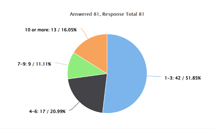
Of those who responded, 30% were solo and the remainder formed part of a group, with just over 50% of responders having completed between 1 and 3 Challenges.
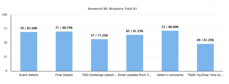
We asked which sources of information supplied by the Coordinators/Vetters was found to most useful? The Event Details, Final Details and Vetter’s Comments all scored highly (around the 90% mark), with the TGO Challenge website dipping to the 70% mark and the TGO YouTube channel just over 60%. We are looking at refreshing the website in the future to try and make it more intuitive; and the TGO YouTube channel has a generally lower hit-rate as it is aimed at the less-experienced Challenger, so is probably less frequented by regular participants. However, even for experienced Challengers, the videos are a useful reminder of how we like the Route Sheet information presented as well as guidance on other topics such as GPX files, using OMN, Grid References etc, and as part of the website refresh exercise, we will look to ensure the links to the You-Tube videos are more clearly signposted.
The online Route Sheet was introduced this year and, as can be seen in the table below, although there were a few Challengers who weren’t too enamoured, it was generally popular with over 85% of those who responded finding it reasonably straightforward to use.
There are some known limitations in the application we use (Cognito Forms) that caused issues for a few Challengers, such as: no colour choice/bolding of text; and the lack of an autosave function. What we didn’t get this year was the usual problems of the old Word document formatting going awry, and those who use Mac computers having their annual torrid time with both the MS Word and pdf formats.
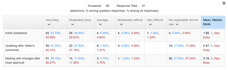
The updating of the Route Sheets appears to have caused a few more issues and we’ll be addressing that by always enabling the ‘Save & Resume’ function for updates rather than leaving it to the Challenger to request it.
There were several comments asking for a pdf/word version of the Route Sheet to be provided. In fact, a Word version of the route sheet was sent as an attachment to the acknowledgement after route submission. We will change the covering email to draw attention to it.
In addition, the formatting of the Word version of the 2026 Route Sheet has been ‘tweaked’ a bit to make each day’s Route Description entry more distinct, as requested by several respondents.
We will continue to use the online version of the Route Sheet for future Challenges; however, if participants are having difficulty using it, please feel free to contact the Coordinators, who will only be too willing to help.
There was a question on which resources were used to plan routes, which had a large and varied response. We had all the usual reference material used, as shown in the table below; however, there were over 30 other resources cited, which are too many to mention here, if you are interested in seeing the list, please request a copy from the coordinators
The Vetters’ comments were, as usual, welcomed by all Challengers, which we’re sure will please the Vetters for all their hard work. 85% of responders found the comments ‘helpful when planning or walking your route’ and 15% found them ‘interesting but nothing of significance was new to you’. We imagine that the latter group are probably largely from experienced Challengers, whose Challenge knowledge in some cases is probably at least as good as the Vetters themselves.
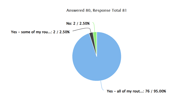
The next few questions revolved around the use of digital mapping in route planning and execution. The results show that 95% of respondents used digital mapping to plot their entire route, with 2.5% using it to plot some of their route, as shown below.
Of those who did use digital planning, 88% provided the associated GPX files with their Route Sheets, which was a truly great response rate.
We are planning, for TGOC 2026, to have the option to use the submitted GPX files as the primary method of following a route and for vetting Route Sheets, rather than the current written route description. In this case a Route Sheet would still be needed, but the level of detail required in the written description will be far less. These will be known as GPX-led Route Sheets, more of which will be released in the near future.
For those who are less comfortable with the use of digital plotting etc, a clearly written Route Sheet will remain perfectly acceptable.
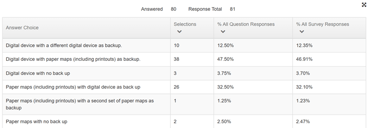
The question on the how Challengers navigate shows that digital navigation apps have become the norm on the event, with over 95% of respondents using a digital navigation tool as their primary or secondary method (see table below), with the same percentage carrying a physical compass. It was pleasing to see that almost 94% of Challengers did take a back-up method of navigation (digital or paper); however, there are still a small number who do not. We strongly recommend that a back-up method is carried, be it a digital device or a set of maps.
There appears to have been no great problems with contacting Challenge Control this year, other than from a few areas where the phone signal was patchy. In general, the phone signal coverage seems to be improving year-on-year in Scotland, which is pleasing to see. From a Challenge Control perspective, this really helps as it is easier for Challengers to call us (and vice versa) and there were no occasions where we shut up shop for the night with any concerns over outstanding phone-ins – a very big ‘Thank you’ from Control.
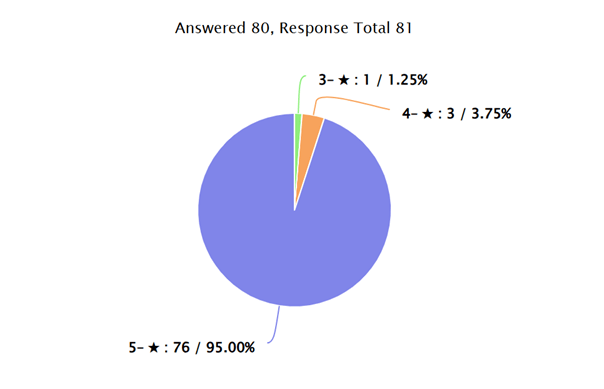
Once again, Challengers reported as being happy with the service that the Coordinators, Vetters and Challenge Control provide, as in the main we received a 5-star rating. We must be doing something right! Thank you for your support.
There were several suggestions for videos to be produced covering various Challenge topics, which we’ll review and consider – some of which we had already noted as action items, such as Route Sheet detail, an online seminar, and a general guide to planning a route, all of which would be aimed at new Challengers.
Once we have time, we’ll see what we can do…
So in summary, we seem to be hitting the right spots, but there are still areas that we could improve and some innovation that we can introduce. Thank you to all those who took the time to complete the survey.